Small Mid waves to end the week, average thereafter

South Australian Forecast by Craig Brokensha (issued Wednesday 30th January)
Best Days: Mid Coast tomorrow afternoon and Friday morning, South Coast magnets Saturday morning
Recap
Great waves across both coasts the last couple of days with strong pulses of W/SW and SW groundswell with morning offshores and relatively weak sea breezes. This morning was the pick down South with super clean and lined up surf across the coast with plenty of size.
Today’s Forecaster Notes are brought to you by Rip Curl
This week and weekend (Jan 31 – Feb 3)
I hope you've made the most of the last few days across the South Coast as we're in for a poor end to the week.
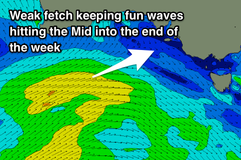
The current groundswell will continue to ease, but a new mid-period and reinforcing W/SW swell should steady wave heights through tomorrow. This swell has been generated the last couple of days by a broad and elongated fetch of strong W/SW winds extending from south of WA up towards the Bight.
The Mid Coast should hang in at 1-2ft on the favourable parts of the tide tomorrow and Friday morning, while the South Coast should see 3ft waves persisting off Middleton, easing from a similar size Friday.
 Winds tomorrow morning will be average for the South Coast and not great for the Mid with a S-S/SW breeze, improving late afternoon as it tends S/SE. Friday will be cleaner on the Mid with an E/SE offshore and the South Coast may see winds tip E-E/NE through the morning if we're lucky.
Saturday will be much cleaner down South with a NE-N/NE offshore but size wise, there's only expected to be a small easing 2ft wave off Middleton, tiny on the Mid Coast and to 1ft.
Sunday will be clean again through the morning with a N'ly offshore ahead of a front and gusty afternoon SW change but with small to tiny leftovers.
This change should bring a new increase in W/SW windswell across the Mid Coast Monday to 1-1.5ft. Also in the mix should be some long-period and inconsistent SW groundswell, generated by a strong polar low that's currently just east of Heard Island. The South Coast will offer the most size, with building sets to a very inconsistent 2-3ft into the afternoon, mixed in with S'ly windswell and fresh S/SE winds.
A slightly more consistent and bigger S/SW groundswell is due Tuesday, produced by another polar low that will form closer to us and remain at strength a little longer. Winds will remain poor though for the South Coast and out of the SE tending S/SE, with tiny sets on the Mid. We'll have a closer look at this Friday though.