Good W/SW swells to come for the Mid Coast

South Australian Forecast by Craig Brokensha (issued Wednesday 5th December)
Best Days: South Coast magnets tomorrow morning, Mid Coast late Friday and Saturday morning, Mid Coast Monday
Recap
Plenty of swell left across the South Coast yesterday with clean though lumpy conditions under a variable wind. The Mid Coast also cleaned up with fun 1ft to occasionally 2ft sets on the magnets with favourable winds most of the day.
Today the swell has become tiny on the Mid Coast, much better down South with plenty of size left to 3ft off Middleton though morning sick early. It's since cleaned up creating fun waves across most breaks.
Today’s Forecaster Notes are brought to you by Rip Curl
This week and weekend (Dec 6 - 9)
We'll see the swell continuing to ease through tomorrow back from a small 1-2ft max at Middleton, though more likely 1-1.5ft with Waits and Parsons the only chance for a surf under a favourable N/NE offshore. Winds should remain good all day and only tend N/NW into the afternoon.
Friday morning looks clean again but tiny with a low point in swell, but into the afternoon we should see our new mid-period W/SW swell filling in.
This has been generated the last couple of days by a broad, slow moving but relatively weak storm west-southwest of WA.
The Mid Coast looks to benefit the most from the swell, with it building to a good 2ft later in the day on the sets, easing slowly from a similar size on Saturday morning.
Middleton isn't expected to see much size, with 2ft+ sets later in the day, easing from a similar size Saturday morning.
 Winds will be average for the South Coast though and onshore with a SW change moving through during the day, bumpy also on the Mid, but a late swing to S/SE breezes should provide fun options for the late.
Saturday S/SE-S/SW winds will favour the Mid Coast, while the South Coast will be poor and onshore, similar Sunday with fresher SE-S/SE winds.
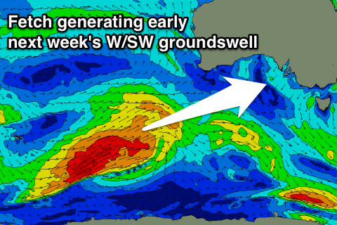
As touched on last update, we're due to see a stronger but inconsistent W/SW groundswell filling in early next week.
This will be generated by a strong polar front developing around the Heard Island region and projecting a fetch of W/SW gales slowly up towards and then under WA while weakening.
The swell should arrive overnight Sunday and peak Monday to a good 2-3ft on the favourable parts of the tide on the Mid Coast and 3-4ft off Middleton.
A SE breeze will favour the Mid Coast again, while as the swell eases into the middle of next week we'll continue to see persistent E to S/SE winds.
Check back here on Friday for one last look at how Monday's swell is tracking.
Comments
Green room
First real swell for the mid since the blow ....itll be interesting to see what's working after the sand shifting.