Very dynamic period ahead with tons of swell from late in the weekend

South Australian Forecast by Craig Brokensha (issued Wednesday 28th November)
Best Days: South Coast Friday mid-morning to early afternoon, possibly late on the Mid Coast, Saturday morning South Coast, early Monday South Coast, Tuesday both coasts
Recap
A continuation of poor surf yesterday, flat on the Mid and small to tiny with strengthening onshore winds down South, terrible again today with a weak windswell across both regions.
Today’s Forecaster Notes are brought to you by Rip Curl
This week and weekend (Nov 29 – Dec 2)
We've got another lay day tomorrow as any weak S'ly windswell seen through today eases along with lingering S/SE winds. It'll be a lot cleaner than today but very and small.
We've got better surf prospects on Friday and from the weekend.
Firstly a new SW swell is due later tomorrow ahead of a peak Friday morning, generated earlier this week but a storm east of Heard Island, dipping south-east towards the polar shelf under WA.
Middleton should see 2ft to occasionally 3ft sets, with 1ft+ waves on the favourable parts of the tide on the Mid Coast, with a light variable morning breeze. There'll likely be some morning sickness early, with improving conditions through the morning ahead of afternoon sea breezes.
We'll see our stronger W/SW groundswell filling in through the afternoon, easing from a similar size on Saturday morning, produced by a more intense and elongated fetch of W/SW gales that are currently passing south of WA's Cape Leeuwin.
The Mid Coast may see 1-2ft sets with the push of the tide Friday with a late offshore wind, holding that size on the favourable parts of the tide Saturday, with better 3ft+ waves off Middleton (4ft off Goolwa).
Winds on Saturday will be best for the South Coast with an early fresh N/NE'ly, tending N/NW early afternoon ahead of an late W/SW change.
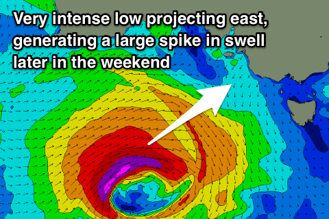 This change will be linked to a vigorous low encroaching on us under the influence of a strong node of the Long Wave Trough across the Bight.
A large new long-period W/SW-SW groundswell will be produced by this low, with it developing south-west of WA and projecting a fetch of severe-gale W/SW winds through our western swell window through the end of the week, stalling south-west of us through Saturday in our south-western swell window.
The groundswell is due to arrive later Sunday morning and build to 2-3ft on the Mid Coast later in the afternoon, but with no help from the tide, with Middleton building to 4-6ft.
Winds will be generally onshore out of the W/SW, with an early W/NW'ly likely around Victor though with a temporary low point in swell ahead of the afternoon increase.
Into Monday we're expected to see a secondary frontal system piggy-backing over the top of the low and clipping the South Coast, bringing W/NW tending SW winds and more large though mid-period surf for the afternoon, easing slowly through Tuesday as winds swing back to the east.
The Mid Coast looks to fare best under this scenario with good clean easing surf from the 2-3ft range, but check back here on Friday for an update on how this frontal progression is tracking.