Small window on the weekend, average until later next week

South Australian Forecast by Craig Brokensha (issued Friday 23rd November)
Best Days: Saturday morning South Coast, Mid Coast next Thursday
Recap
How quickly did things escalate Wednesday afternoon. The severe-low deepening off Kangaroo Island started to move in, bringing a very large stormy increase in swell on the Mid Coast with gale-force winds.
This eased off through yesterday as the low continued east with easing stormy surf from 3-4ft early, down to 2-3ft into the afternoon, tiny today. The South Coast was a large onshore mess as the swell filled in from the back side of the low, still poor and onshore today but on the ease.
Today’s Forecaster Notes are brought to you by Rip Curl
This weekend and next week (Nov 24 - 30)
Our window of cleaner peaky conditions tomorrow is still on the cards with another mid-latitude low that formed across inland WA currently tracking east-southeast towards us.
This will tip winds E/NE-NE through tomorrow morning creating peaky clean faces with a S/SE windswell easing from the 3ft range across most breaks, while the Mid Coast will be tiny to flat.
The low will weaken and continue east through Sunday, bringing a return to SE tending S/SE winds though no decent swell.
We'll see the surf continuing to drop in size into Monday and Tuesday with no real improvement in conditions.
Winds will become light but linger from the S/SE-E/SE on Monday morning down South but Middleton will hardly be 1-2ft and more than likely tiny.
 Tuesday morning looks cleaner with a more variable breeze ahead of a strong W'ly change but only tiny surf.
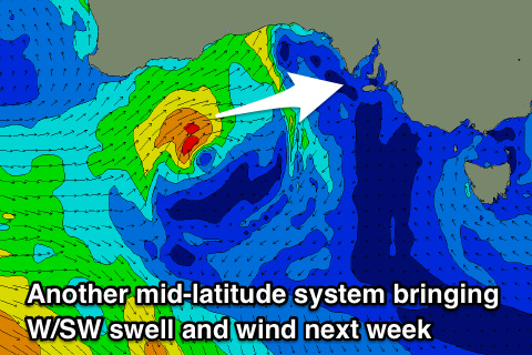
The strong W'ly change will be linked to yet another mid-latitude storm deepening and moving in from the west, pushing fairy quickly across us through Tuesday afternoon and Wednesday.
An initial fetch of strong to gale-force W/SW winds should be produced in our western swell window, high in the Bight on Monday before breaking down a little and then bringing strong SW winds as it passes across us Tuesday evening.
We'll sea a fun W/SW swell generated from the initial W/SW fetch filling in Wednesday and coming in around 2ft+ on the Mid Coast but this will be mixed in with a stormy increase in windswell generated later Tuesday to 2-3ft, easing from 3ft Wednesday morning.
The South Coast will also see an increase in S/SW windswell on Wednesday likely to 3-4ft or so.
The low will clear Thursday with small bumpy easing 1-2ft waves on the Mid Coast (with a S'ly wind), onshore and bumpy down South.
Longer term we've finally got some better W/SW groundswell on the cards for later in the week and next weekend, but winds could be an issue. Check back here Monday for an update on this and have a great weekend!