Strong swell building through the weekend, cleanest as it eases

South Australian Forecast by Craig Brokensha (issued Friday 9th November)
Best Days: South Coast magnets tomorrow morning, South Coast later morning Sunday and early afternoon ahead of the sea breeze, Monday South Coast, and Tuesday morning
Recap
A mix of reinforcing W/SW and SW swell kept wave heights up across both coasts yesterday, 3-4ft off Middleton and the 2ft range on the Mid working the tides (best into the afternoon). Winds remained favourable for protected spots all day down South and variable on the Mid.
Today the South Coast is again great with a light offshore wind and sets hanging in at 3ft off Middleton (though now on the ease) with tiny 1ft waves on the Mid Coast.
Today’s Forecaster Notes are brought to you by Rip Curl
This weekend and next week (Nov 10 - 16)
We'll see the swell continuing to ease this afternoon and into the start of the weekend, but conditions will be great down South through the morning with a light N'ly offshore wind.
Middleton will be back to a small and slow 2ft max on the sets, best at Waits and Parsons for keen surfers ahead of sea breezes. The Mid Coast will be tiny.
 A low point in swell is expected on Sunday morning, but our strong new long-period S/SW groundswell for the afternoon is still on track.
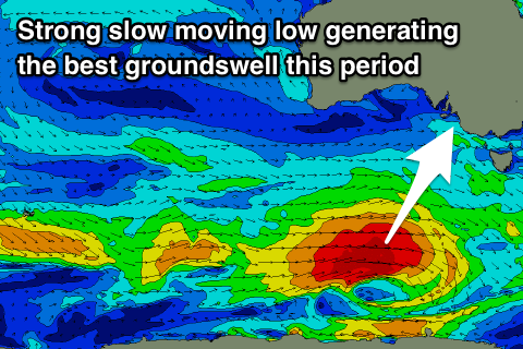
A strong polar low formed south-west of WA yesterday, with an initial small and fast moving fetch of severe-gale to storm-force W'ly winds now slowing and broadening.
We're seeing a great fetch of gale to severe-gale W/SW winds generated south of the country, with the low expected to push slowly east-southeast and out of our swell window tomorrow morning.
A moderate sized long-period S/SW groundswell will travel up towards us, arriving through Sunday morning and building strongly into the afternoon.
Middleton should kick to a good 4ft on the sets into the afternoon, tiny on the Mid Coast with the swell being too south in nature.
A light morning E/NE-NE offshore will unfortunately give into S/SE sea breezes, creating bumpy and average conditions but there should be window of decent conditions as the swell builds.
Monday looks the day to surf with a great offshore N/NE wind, possibly tending variable but likely giving into sea breezes mid-afternoon. Middleton should ease back from a good 3ft to possibly 4ft, smaller Tuesday and back to 2ft+ with a morning NW offshore ahead of a SW change.
Our next increase in swell will arrive Wednesday afternoon and peak Thursday, generated by a persistent fetch of pre-frontal strong to gale-force W/NW tending W winds moving in from the south-east Indian Ocean and under WA before dipping south-east away from us.
A secondary front may piggy-back on the back of this front generating a secondary pulse of swell for Friday, but back to Thursday's pulse and we're likely to see 3ft+ sets off Middleton with 1-1.5ft waves on the Mid Coast though with a S/SE breeze as a strong high moves in behind Wednesday's change.
We'll have another look at this Monday though. Have a great weekend!