Lots of swell to come this week

South Australian Forecast by Craig Brokensha (issued Monday 5th November)
Best Days: South Coast early tomorrow, Wednesday and Thursday mornings, Mid Coast Thursday,Friday both coasts
Recap
A building and strengthening W/SW mid-period tending groundswell through Saturday with onshore winds across both coasts, becoming very sizey on the Mid Coast later as winds tended variable.
Yesterday was the day though with clean pumping waves across both coasts with easing 2-3ft sets on the Mid Coast and large clean surf down South with the S/SW groundswell filling in.
Today the swell has backed off though the South Coast is still pumping with clean 3ft sets off Middleton and solid ones out at Waits. The Mid Coast was back to a tiny and bumpy 1-.15ft.
Today’s Forecaster Notes are brought to you by Rip Curl
This week and weekend (Nov 6 - 11)
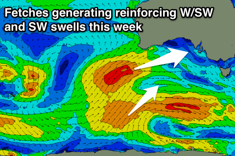
The weekend's W/SW and S/SW swells were the first generated under the influence of a strong node of the Long Wave Trough sitting just west of the Bight.
Over the weekend another vigorous polar low formed under its spell, south-west of WA with a great fetch of severe-gale to storm-force W/SW winds projected through our south-western swell window.
The storm has since weakened, with a large long-period SW groundswell now heading towards us, with it due to arrive this evening and peak tomorrow morning.
 Middleton should come in at a strong 4-6ft on the sets, only small and coming in at 1-2ft max on the Mid Coast.
Also in the mix on the Mid Coast though will be a building mid-period W/SW swell that's due to peak Wednesday.
This will be generated by a weaker cold front spawning off the back of strong low over the weekend, pushing under WA and through the Bight tomorrow.
The front will bring gusty W/SW winds tomorrow (W/NW early on the South Coast) with a building windswell on the Mid Coast to a similar size as the groundswell (1-2ft), followed by stronger mid-period energy Wednesday to 2-3ft on the favourable parts of the tide, easing slowly Thursday but still coming in around a similar size.
The South Coast will ease back Wednesday, slowed by some reinforcing mid-period SW swell Thursday generated by a weak SW fetch on the tail of the low as well.
Our models are over-forecasting the size, but Middleton should still see 3-4ft sets through the morning, with surf hanging around 3ft Thursday before easing from 2-3ft on Friday morning.
Winds will unfortunately be generally onshore from the W/SW-SW through Wednesday and Thursday, W/NW for periods early each morning around Victor. A variable wind will hopefully be seen Thursday on the Mid Coast, with Friday seeing better NW offshores down South (NE on the Mid Coast) with mid-afternoon sea breezes.
The weekend will be smaller again with small 2ft leftovers off Middleton though with a light W/NW-NW offshore down South.
A small mid-period SW swell is expected on Sunday but to no major size, though into the afternoon and more so Monday a slightly better SW groundswell is on the cards, but check back here Wednesday for more on this.