Plenty of S/SW pulses but with dicey winds
South Australian Forecast by Craig Brokensha (issued Friday 18th May)
Best Days: Saturday morning, Tuesday morning protected breaks, Wednesday morning, Thursday and Friday mornings
Recap
A drop in swell from Wednesday's fun pulse of swell on the Mid Coast, while the South Coast saw good sized sets hanging off Middleton with a light to moderate onshore wind.
This morning a large and powerful S/SW groundswell peaked with sets to 4-6ft across the South Coast and favourable winds for more protected spots, with poor 1ft waves on the Mid.
Today’s Forecaster Notes are brought to you by Rip Curl
This weekend and next week (May 19 – 25)
These notes will be brief as Ben’s on holidays.
This morning's large S/SW groundswell should ease back through tomorrow, dropping from 3ft to possibly 4ft across the Middleton stretch early, down to 2-3ft through the day.
Winds are a little dicey but likely light and variable, possibly lingering from the S'th, but with the strength of the swell, Middleton should still be fun.
The Mid Coast will be tiny and clean with an early light SE breeze.
Sunday is now looking a little hit and miss with a low point in swell (maybe 1-2ft Middleton) and early light W/NW winds, swinging fresh W/SW through the morning.
A frontal system pushing towards Tassie and strengthening late in our swell window on Saturday should produce some new S/SW swell later in the day, with a better groundswell for Monday morning.
Middleton may reach a bumpy onshore 2-3ft late Sunday, but Monday looks better with 3ft to possibly 4ft sets off Middleton and 0.5-1ft waves on the Mid Coast.
 Winds are dicey and expected to be from the W/SW, but there's an outside chance of early W/NW winds around Victor.
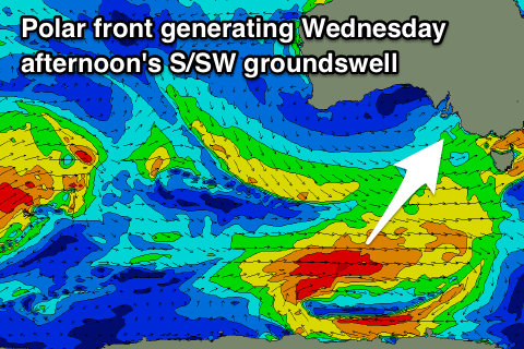
A drop in size from the 3ft range is expected on Tuesday as winds return to the W/NW for a period through the morning, while a new moderate sized S/SW groundswell is due to fill in Wednesday.
This will be produced by a strong and good storm tracking south-east from the Indian Ocean, along the polar shelf while generating a fetch of W'ly gales in our southern swell window and then passing under Tassie.
The swell will build through Wednesday and kick from the 2-3ft range off Middleton in the morning to a better 3-4ft after lunch. Winds are an issue again though with an early W'ly breeze swinging S/SW with a change through the day.
More variable breezes should create clean fun waves Thursday morning as the swell easing, similar Friday.
The Mid Coast isn't due to any real size from these swells as they arrive more from the south than west, but from next weekend onwards, there's some more positive activity. More on this Monday. Have a great weekend!

