Easing improving surf, new W/SW swells from Friday
South Australian Forecast by Craig Brokensha (issued Friday 22nd December)
Best Days: Protected spots South Coast tomorrow morning, Wednesday morning at swell magnets, protected spots South Coast Saturday morning
Recap
Merry Christmas from the Swellnet team. Great waves across the South Coast Saturday morning with an inconsistent but good S/SW groundswell to 3ft off Middleton, larger at more exposed breaks. The Mid Coast was clean but back to a tiny 1ft+.
Onshore winds moved in yesterday creating poor conditions as the Mid Coast eased further, while today we've got strong onshore winds down South and a sizey sloppy swell, and tiny clean sets on the Mid Coast.
Today’s Forecaster Notes are brought to you by Rip Curl
This week and weekend (Dec 26 - 31)
We've currently got a mix of mid-period SW swell and S/SE windswell across the South Coast, but both of these will ease as winds improve tomorrow, best Wednesday.
An E/NE-NE wind will create cleaner but peaky surf tomorrow, easing from 2ft to possibly 3ft off Middleton, flat on the Mid Coast. A N/NE tending N/NW wind ahead of late sea breezes will create clean conditions most of the day Wednesday, but Middleton is due to be tiny and only around 1-1.5ft, with 2ft+ sets at Waits and Parsons early, easing through the day.
Thursday will be a lay day as the surf bottoms out and a weak surface trough moves through, bringing onshore S'ly winds.
 From Friday and more so the weekend we should see some new W/SW swell filling in.
Firstly, long period energy showing on the charts from Wednesday won't have any size attached to it, with it being generated south of South Africa last week.
We'll see a very slight uptick in size Friday from an initial weak front that's currently south-west of WA, but don't expect anything over 1-1.5ft off Middleton, while the Mid Coast should come in at 1ft, with possible 1.5ft sets on the favourable parts of the tide.
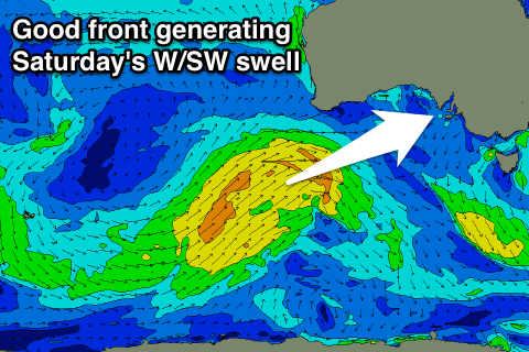
A better W/SW swell is due on Saturday, generated by a closer and broader, but still weak mid-latitude front projecting towards WA tomorrow and Wednesday, passing just south of the Bight Thursday.
We'll see this swell provide good 2ft surf on the Mid Coast while the Middleton stretch should build to 2ft to occasionally 3ft. Winds look average though with S/SW tending SW breezes Friday and W/NW tending W/SW winds Saturday, favouring protected spots down South.
An even stronger swell is likely Sunday from a third stronger front developing in our swell window, but more on this Wednesday.

