Various swells incoming with improving winds
South Australian Forecast by Craig Brokensha (issued Monday 18th December)
Best Days: Thursday morning both coasts, Friday morning South Coast (keen surfers for tiny waves on the Mid, Saturday morning South Coast
Recap
Good clean waves Saturday across both coasts with a peak in SW swell and variable tending light offshore winds down South with 3ft sets off Middleton, while the Mid Coast offered clean 1-1.5ft sets.
Sunday was more peaky down South with an E/NE tending NE wind and swell hanging in at 2-3ft off Middleton. The Mid Coast dropped back to a tiny 0.5-1ft.
Today conditions were again clean on both coasts but with no swell on the Mid Coast and 2ft leftovers off Middleton, better at Waits and Parsons.
Today’s Forecaster Notes are brought to you by Rip Curl
This week and weekend (Dec 19 - 24)
Today's swell will continue to ease through tomorrow and Middleton will be tiny and clean (ideal for beginners) and a strengthening NW tending W/NW breeze. Waits should have a couple of OK waves, but not worth the drive from Adelaide.
The Mid Coast should see a building mix of windswell and long-range groundswell under the strengthening W/NW'ly, reaching 1-2ft later in the day, though messy.
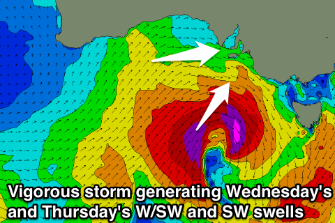
This strengthening W/NW'ly will be linked to deepening low pressure system under the country, the result of a strong cold low off WA coast dipping south-east and combining with a moisture laden inland surface trough.
We'll see a significant re-intensification of the low in our swell window, with a fetch of strong W/SW winds through the Bight in the Mid Coast's swell window, followed by a much more significant fetch of severe-gale to storm-force W/SW winds in our south-western swell window.
 We'll see the swell build and strengthen out of the SW on Wednesday down South ahead of a peak Thursday morning. The morning is likely to be small and windswelly with 2ft surf off Middleton (under a W/NW breeze), but a strong kick is due later in the day, reaching 3-4ft, though bumpy.
The Mid Coast should see the W/SW swell coming in at 2-3ft during the day though fresh to strong but easing W/SW tending SW winds will create poor conditions.
A peak in SW swell is due Thursday morning across the South Coast to 4ft off Middleton, while the Mid Coast looks to be more in the 2ft+ range.
Winds are looking OK but not perfect with a light and possibly variable SW'ly across the South Coast, and possibly tending light S'ly on the Mid. Sea breezes will develop through the afternoon creating bumpy conditions.
The swell will ease later Thursday and continue to drop into Friday with more favourable light N/NE-NE breezes. The Mid Coast will likely be back to a tiny 1-1.5ft.
Later in the day though and more so Saturday a good new pulse of reinforcing S/SW groundswell is expected, generated by a strong polar low generating a fetch of gale to severe-gale W/SW winds in our southern swell window.
This long-period S/SW groundswell may be seen on dark Friday, but a peak is expected Saturday morning to 3-4ft off Middleton, while the Mid Coast is expected to hang around 1ft.
Conditions are looking excellent down South with a N/NE offshore before sea breezes kick in, while come Sunday a ridge of high pressure moving in from the west will bring poor S/SE winds.
We'll confirm the weekend's swell and local winds on Wednesday.

