Average couple of days, large surf for the weekend
South Australian Forecast by Craig Brokensha (issued Monday 25th September)
Best Days: Keen surfers, protected spots tomorrow morning on the South Coast, Friday South Coast, protected spots all weekend down South
Recap
Great waves for exposed breaks Saturday morning down South with the cleanest conditions during the morning. Windier yesterday as some new swell built through the afternoon.
The Mid Coast saw clean easing 1-1.5ft sets on Saturday while a stormy swell built through yesterday from 3ft in the morning.
Today the swell was on the ease but conditions much cleaner with a light to moderate onshore winds and 2-3ft sets across the Mid, while the South Coast saw some fun lumpy waves in the 2ft range off Middleton, but a SW change has since moved through.
This week and weekend (Sep 26 – Oct 1)
The coming couple of days aren't too special at all with a lift in S/SW swell later today and tomorrow morning in the wake of a change due to be met with average and fresh E/NE winds.
 This will only favour protected spots like Goolwa and Parsons with easing 2-3ft sets. The Mid Coast will become tiny and fading from 1ft.
Wednesday will be cleaner but tiny with a freshening NW tending W/NW breeze. Later in the day we may see some new S/SW groundswell from a late forming but intense polar front in our southern swell window.
Thursday morning is a better chance to see this swell though an onshore change linked with to mid-latitude low moving across us. This will bring SW winds at dawn, easing and tending W/SW through the day.
Middleton looks to come in around 2ft with larger sets at Waits and Parsons. A small W/SW swell should be generated by this low for the Mid Coast, coming in at 1-2ft but with those onshore winds.
Of much greater significance is the polar front activity to come late week.
An initial weak polar front should generate some new mid-period S/SW swell for Friday coming in at 3ft to occasionally 4ft off Middleton along with fresh W/NW winds. The Mid Coast will be messy with 1ft+ surf.
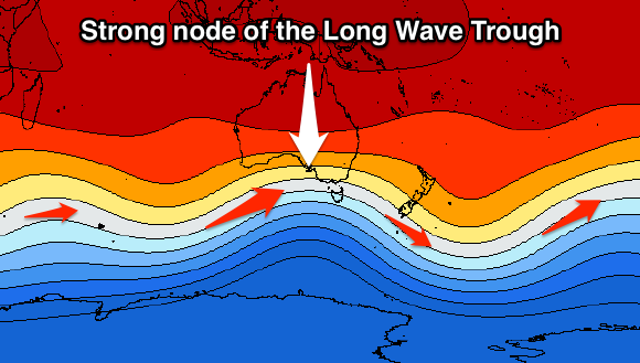
A much more significant cold-outbreak will fire up behind it, mentioned the last few updates. This strong polar frontal progression will be linked to a strong node of the Long Wave Trough strengthening over the Bight and the south-east of the country later this week.
The secondary polar front will generate a fetch of severe-gale to storm-force W/SW tending SW winds through out south-western swell window before projecting up and into us Friday afternoon and evening.
 What we'll see is some large consistent close-range SW swell generated by the strong front pushing into us Friday, filling in Saturday morning, with larger long-period S/SW groundswell energy later in the day/Sunday morning.
Middleton should be in the 6ft range Saturday morning, increasing a touch further through the afternoon, while Sunday should see large surf easing from 6ft to occasionally 8ft.
The Mid Coast looks to offer surf in the 2ft range on Saturday, easing from a similar size Sunday.
Winds are't ideal and look to be W/SW for the most part all weekend, but the Victor region should see periods of W/NW winds early each morning.
There is plenty more reinforcing SW energy due into early-mid next week produced by persistent broad and strong frontal activity, but more on this and the weekend's swell on Wednesday.

