Average Saturday, great Sunday with a large swell for Tuesday. cleanest Wednesday
South Australian Forecast by Craig Brokensha (issued Friday 15th September)
Best Days: Sunday South Coast, Tuesday Mid Coast, Wednesday and Thursday South Coast
Recap
Average onshore waves in the 2-3ft range across the Mid Coast yesterday, back to a smaller 2ft this morning as onshore winds continued.
The South Coast was OK in protected spots with a mix of W/SW groundswell and mid-period SW swell, but today is much better with cleaner conditions and more organised 3-4ft surf off Middleton.
The swell should ease off a touch later as winds hold from the W/NW.
This week and weekend (Sep 16 - 22)
These notes will be brief as Ben’s away today.
Tomorrow is still looking poor with a cold front passing under us this evening bringing onshore S'ly tending SE winds down South, while the Mid Coast will be clean but fading in size from 1-1.5ft.
A tight embedded low in the front passing under us is now due to develop today (contrary to Wednesday's downgrade), with a tight fetch of severe-gale SW winds forming late in our southern swell window.
This will generate a moderate sized S'ly groundswell for later tomorrow, mixed in with some mid-period S/SW swell.
Our models are over-forecasting the size considerably over the weekend, with only 3ft waves due off Middleton tomorrow, kicking late to 3-5ft, then easing back from 3ft+ Sunday morning. There'll be some distant SW groundswell from a polar low in the mix Sunday morning, with all swells easing through the afternoon, back to the small 2ft range Monday.
The Mid Coast is expected to be tiny and easing from 1ft Sunday.
Winds will swing right back to the N/NE and be fresh all day Sunday, creating excellent conditions.
 W/NW-NW winds will create clean conditions Monday morning ahead of a W/SW change.
Later in the day and more so Tuesday we'll see the large long-period SW groundswell mentioned on Wednesday filling in.
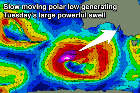
A vigorous low is due to develop south-west of WA tomorrow, producing a slow moving and expansive fetch of severe-gale to storm-force W/SW winds through our western and south-western swell windows.
The low will project slowly east towards us while continuing to generate fetches severe-gale to storm-force winds.
A large long-period SW groundswell will result, building later Monday and peaking Tuesday to 3ft on the favourable parts of the tide across the Mid Coast and 6ft+ across Middleton though with onshore SW tending S winds. This will favour the Mid Coast while Wednesday is the day for the South Coast with plenty of size still left over and offshore N winds.
We'll look over this swell one more time Monday. Have a great weekend!

