Workable window early tomorrow, better over the weekend
South Australian Forecast by Craig Brokensha (issued Wednesday 6th September)
Best Days: Protected spots tomorrow morning on the South Coast, Saturday morning South Coast, Sunday South Coast, Tuesday South Coast
Recap
Messy choppy waves in the 3ft range across the Mid Coast yesterday while the South Coast started OK and in the 4-5ft range ahead of a larger pulse of swell into the afternoon but with onshore winds.
Today even stronger levels of S/SW groundswell are pushing into the South Coast and winds were OK early but have since started to swing more W/SW. We should see the S/SW groundswell remaining large all day but winds remain average and from the W/SW.
This week and weekend (Sep 7 - 10)
Today's large and powerful S/SW groundswell will start to ease off into tomorrow, dropping back from 4-5ft+ across exposed breaks tomorrow morning, while the Mid Coast will is likely to drop back to 1-1.5ft.
Winds tomorrow look similar to today, with fresh W/SW breezes in general, but Victor may see W'ly breezes for a short period.
Our onshore change due into Friday is still on track, but the swell from it has been downgraded a touch.
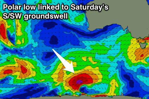
A strong polar low that's currently forming south-southwest of WA will generate a tight fetch of severe-gale W/SW winds before a cold front spawns off it, pushing up and into Victoria tomorrow afternoon and evening. We'll see SW gales generated late in our swell window, generating a close-range S/SW swell Friday.
 Middleton should persist around 3-4ft through the morning, easing into the afternoon with tiny waves on the Mid Coast.
Winds are still looking average with lingering S/SW winds in the wake of Thursday night's change.
The weekend is still the pick, with a better S/SW groundswell pulse due from the initial polar low on Saturday, offering good 3-4ft sets across Middleton, easing through the day and down further from 3ft Sunday.
The models are combining the close-range mid-period S/SW swell with this new long-period S/SW groundswell and over-forecasting the size all weekend. The Mid Coast will be tiny to flat due to the unfavourable southerly swell direction.
Winds on Saturday should tend variable and light out of the W/NW during the morning ahead of better straighter and fresh N/NE winds on Sunday.
Longer term we should see a new long-period SW groundswell filling in Tuesday, followed by some more consistent W/SW energy late week, but more on this Friday.

