Large W/SW groundswells for Sunday, easing into early next week
South Australian Forecast by Craig Brokensha (issued Friday 28th July)
Best Days: Sunday South Coast, early Monday South Coast, Tuesday South Coast, Wednesday Mid Coast
Recap
Great waves across the South Coast yesterday with improving conditions as a stiff offshore kicked in along with a good easing S/SW swell. The Mid Coast was tiny and bumpy.
Today a new W/SW swell has kicked up wave heights across both coasts with light local offshore winds. Magnets on the Mid were seeing 2ft sets, with lumpy but improving 2-3ft waves off Middleton.
This weekend and next week (Jul 29 – Aug 4)
Tomorrow isn't looking too flash, with this morning's increase in W/SW swell due to ease back this afternoon, fading further overnight leaving small fading 1-1.5ft sets across Middleton under a fresh to strong N/NW tending W/NW breeze.
The Mid Coast will offer poor conditions with a mix of easing W/SW swell and building windswell.
Of greater importance is the large W/SW groundswells into Sunday.
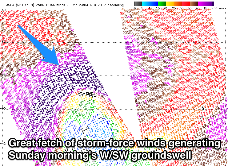
Satellite observations overnight have picked up an incredible fetch of storm-force W'ly winds aimed in our western swell window, at the centre of a vigorous mid-latitude low sitting off the WA coast.
This will generate an initial pulse of long-period W/SW groundswell that is likely to arrive just after dark tomorrow, peaking Sunday morning.
 A continued fetch of severe-gale to storm-force W'ly winds through today, followed by weakening severe-gale W/SW winds pushing east tomorrow should generate a secondary larger W/SW groundswell for Sunday afternoon.
Size wise, Middleton should see strong 4-5ft sets Sunday morning, building more to the 6ft range through the day.
The Mid Coast is likely to be in the 3ft range all day with 4ft sets into the afternoon, though fresh W/NW tending late W/SW winds will favour protected locations down South.
Winds on Monday are now looking suss with a small weak trough expected to move into the South Coast early morning. This will bring W/SW tending SW winds to both coasts, but the Victor region is likely to see early W'ly breezes.
The swell will ease back from 4-5ft across Middleton and 2-3ft on the Mid Coast, smaller into Tuesday morning as winds swing back offshore from the N/NE.
From the middle of the week we'll see funky E'ly winds developing, tending more S'ly as a deepening surface trough off the southern NSW coast forms into a low and stalls.
This will spoil some new inconsistent long-range W/SW groundswells, but the Mid Coast looks to fair well with this combo. More on this Monday, have a great weekend!

