Great waves down South, large and dangerous Saturday
South Australian Forecast by Craig Brokensha (issued Wednesday 21st June)
Best Days: South Coast Thursday and Friday, experienced surfers only Saturday morning, Sunday morning protected spots, Tuesday
Recap
Another fun day of surf down South with solid clean waves yesterday, while the Mid Coast dropped back to the 1-1.5ft range.
This morning the Mid was tiny, while some new swell was building across the South Coast, with clean 3ft sets off Middleton. The swell has kicked further and conditions are still nice with a shallow onshore change.
This weekend and next week (Jun 16 – 23)
This afternoon's building S/SW groundswell was generated by a strengthening cold front pushing up towards Victoria yesterday.
The swell is expected to hold through tomorrow with a reinforcing S/SW pulse keeping Middleton in the 4ft range, easing slightly into Friday.
The swell will be too south for the Mid Coast with tiny 1ft sets due all day.
Winds tomorrow will be great all day with a N/NE tending variable N/NW breeze and then N/NW tending variable winds Friday.
This brings us to the weekend's large and powerful swell event.
A node of the Long Wave Trough is currently strengthening across the Bight and will move slowly east over the coming days, continuing further towards New Zealand over the weekend.
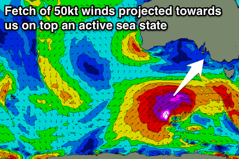
 This has already spawned a vigorous polar front south-southwest of WA, with a fetch of pre and post-frontal gales forecast to be generated in our south-western swell window. This will generate a moderate sized S/SW groundswell alone, but also create an active sea state for a much stronger and more significant storm to move over.
This secondary storm will form tomorrow, projecting a fetch of severe-gale to storm-force SW winds up right through our southern swell window, clipping Bass Strait in Victorian before moving off further east Friday.
With the front moving over the already active sea state we'll see quicker than normal wave growth, resulting in a large long-period S/SW groundswell arriving Saturday and peaking in the large 8ft range across most breaks on the South Coast, with the odd bigger bomb likely at deep water reefs and offshore bommies.
The swell isn't ideally aimed for the Mid Coast, but the sheer size should see some 1-1.5ft+ sets squeezing in through the gulf all day.
Winds are looking excellent as an approaching trough brings N/NW morning offshores, giving into a S/SW change through the day, the timing of which we'll have to confirm on Friday.
The swell will ease back through Sunday from the 4-6ft range and winds look a little less favourable, swinging from the W/NW to W/SW.
Into early next week we're due to see another moderate to large S/SW swell from a third polar frontal system firing up on the tail of the amplified Long Wave Trough moving east. Winds look initially onshore, but more on this Friday.

