Best down South over the coming period
South Australian Forecast by Craig Brokensha (issued Friday 16th June)
Best Days: South Coast Saturday and Sunday mornings, Monday, Tuesday morning
Recap
Great waves across the South Coast yesterday and today, coming in at a clean pumping 3-4ft off the Middleton stretch, while the Mid Coast was only around 1-1.5ft yesterday morning, pulsing to 2ft with a new W/SW swell into the afternoon. This morning the swell was back to a less consistent but clean 1-2ft.
This weekend and next week (Jun 16 – 23)
Today's swells will ease off through the weekend, with some reinforcing SW energy tomorrow morning from a pre-frontal fetch of W/NW gales Wednesday under WA, slowing the trend.
Middleton is expected to ease from 3ft on the sets with 1ft waves on the Mid Coast. Conditions should be clean across both coasts with a variable wind on the Mid through the morning, light NW down South ahead of a weak W/SW change early afternoon.
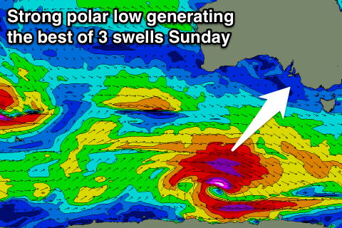
Into Sunday, our three separate new groundswells are still on the cards, but with a downgrade in the third largest one.
The first swell from the W/SW has been produced by a stronger fetch of W/NW gales moving under WA and the Bight yesterday and should provide 3ft sets at Middleton Saturday morning and 1ft+ on the Mid.
 A stronger and broader fetch of polar severe-gale W/SW winds last night and this morning is generating a larger long-period S/SW groundswell which is due to arrive mid-morning, kicking Middleton to a stronger 3-5ft.
The final S/SW groundswell will be produced by a deepening low tracking in quickly from the east tomorrow afternoon and evening, with a burst of severe-gale SW winds generated late in our swell window. With this low being weaker, no larger size is due off this swell.
Now with the three different swells in the water we're likely to see weird and funky double-ups which isn't ideal, so while this combo sounds good, more than likely it won't be.
Winds are looking a little dicey with an early light W/NW breeze due through the morning, giving into a weak S/SE change through the day.
Monday will then be great as the swells eases with N'ly tending variable winds.
Longer term an onshore change and S/SW windswell is expected Wednesday, but into the end of the week a more typical winter frontal progression is expected, generating large swell next weekend, but more on this Monday. Have a great weekend!

