Strong swells for the period, winds are a bit of an issue
South Australian Forecast by Craig Brokensha (issued Wednesday 15th February)
Best Days:
Recap
Tiny waves on the Mid Coast yesterday, near flat today, while the South Coast saw lots of swell to 4-5ft off Middleton and better conditions than Monday but for the most part, average surf.
Today however is pumping with clean solid and easing surf under offshore winds which will give into a W'ly change mid-afternoon.
This week and weekend (Feb 16 – 19)
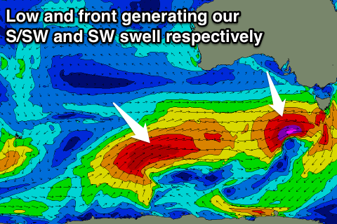
Our solid increase in S/SW groundswell due through tomorrow is on track, with a front that's currently south of the Bight expected to produce a strengthening fetch of severe-gale W/SW winds through our swell window.
A moderate sized S/SW groundswell is expected to arrive late morning (2-3ft early) and kick strongly into the afternoon, coming in at 3-5ft across Middleton late afternoon/evening. The swell should then ease from the 4ft range Friday morning, steadily down through the day.
The Mid Coast should see 1ft sets from the earlier stages of the front, easing from a similar size Friday morning, although some new windswell will build over the top into the afternoon.
Winds tomorrow will be poor at dawn and likely from the SE, but an improvement to variable tending E/NE breezes is due through the morning before sea breezes kick in.
Friday's winds are a little tricky with a strengthening W/SW'ly due as the second polar frontal system pushes up and into us, but the Victor region should see a W/NW'ly all morning.
 The front mentioned above is already generating a fetch of severe-gale W/SW winds through our south-western swell window, but will project towards the Bight while weakening slightly. The front will then continue moving closer to us while slowly weakening Friday and Saturday.
A large SW groundswell should be generated, building through Saturday, peaking late in the day and easing Sunday.
Middleton should increase from 4-5ft to the 6ft range into the afternoon, easing back from 5-6ft Sunday morning. The Mid should see 1-2ft sets into the afternoon, easing back from a similar size Sunday morning.
Conditions are unfortunately looking average with a fresh SW breeze Saturday and S'ly winds Sunday. There is a slim chance for an early W'ly around Victor Saturday morning but it will be short-lived.
Into early next week the swell will continue to ease with E'ly winds Monday but better offshores for the South Coast Tuesday.
Of greater importance is some good W/SW swell due later next week, but we'll cover this in more detail Friday.

