Poor week ahead, small Mid Coast waves Tuesday/Wednesday
South Australian Forecast by Craig Brokensha (issued Monday 21st November)
Best Days: Mid Coast peelers Tuesday and Wednesday, South Coast Thursday morning and Sunday morning
Recap
Good fun waves across the Mid Coast Saturday to 1-2ft on the sets, easing back to 1-1.5ft yesterday while the South Coast was small and lumpy Saturday, much better Sunday with a new swell and developing N/NE breeze ahead of sea breezes.
This morning the swell was holding a similar size with favourable conditions again across both coasts.
This week (Nov 22 – 25)
The coming week is unfortunately looking pretty poor.
The Mid Coast will likely be the best option for a wave, with persistent onshore S'ly to SE winds across the South Coast as a stubborn high develops and spring finally kicks in.
A weak trough currently pushing in from the west is producing a weak fetch of W/SW winds through the Mid's swell window, and this will be followed by a secondary tight but weak low tomorrow, more in the South Coast's swell window.
1-1.5ft sets should persist on the Mid Coast tomorrow afternoon and Wednesday before becoming tiny into the rest of the week.
S/SE winds are due tomorrow morning on the Mid, with S/SW sea breezes and then moderate to fresh S/SE winds all day Wednesday.
The South Coast will be poor until Thursday when a light E/NE'ly may be seen through the morning. Easing surf from 2ft at Middleton is expected, bigger at Waits and Parsons.
Friday will then be tiny as S/SE winds kick in again.
This weekend onwards (Nov 26 onwards)
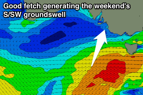
 Some better S/SW groundswell is due over the weekend with more size and power, produced by a strong polar low firing up along the polar shelf then projecting towards Victoria, with a couple of bursts of W/SW gales through our swell window.
The strongest fetch will develop through Friday, with a moderate sized S/SW groundswell resulting.
An increase in size should be seen through Saturday but with S'ly winds, peaking Sunday morning to 3-4ft+ off Middleton with a light morning E/NE'ly. The Mid Coast isn't due to see any size at all.
As the surf eases early next week, another developing high looks to maintain S/SE winds across the state, but more on this Wednesday.

