Large onshore swell tomorrow, cleaner and easing Sunday
South Australian Forecast by Craig Brokensha (issued Friday 4th November)
Best Days: South Coast Sunday and Monday morning, Wednesday morning both coasts (tiny Mid)
Recap
Great waves down South yesterday with a light offshore wind and clean 3-4ft sets, with an afternoon sea breeze creating bumpy surf after lunch. The Mid was a clean 1-1.5ft and relatively clean all day with weak sea breezes.
Today the swell has started to ease, but conditions were great again down South with an offshore wind, while the Mid was a tiny 1ft+. An onshore change is due late afternoon, so get out before then.
This weekend and next week (Nov 5 - 11)
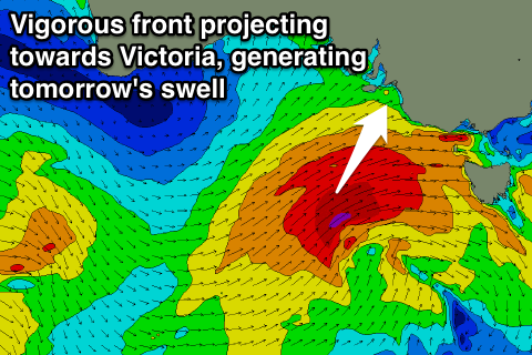
Later today's change is linked to a vigorous cold outbreak approaching from the south-west.
This frontal system has been generating a tight fetch of gale to severe-gale W/SW winds, but this fetch will broaden and maintain its strength right until it pushes under us and into Victoria.
 A large SW groundswell will be generated for us tomorrow but with stormy conditions due to a fresh but easing SW tending W/SW breeze.
Middleton should see easy 6ft sets, if not a touch bigger, with the Mid Coast coming in much smaller and around 1ft to possibly 2ft.
The swell will ease back steadily Sunday as the low moves off quickly to the east, but winds will improve with an approaching front due to steer winds from the W/NW to the NW through the day.
Middleton is expected to ease from 4-5ft early, back to the 3ft range into the afternoon, with tiny fading waves on the Mid.
Unfortunately the strength of this follow up front has been downgraded, with the reinforcing pulse of swell for Sunday afternoon and Monday morning not really happening.
Instead we'll continue to see the South Coast easing from 2-3ft at Middleton and 4ft or so at Waits and Parsons. The Mid will be tiny. Early light winds are expected to give into a S/SW change, so get in well before lunch.
Into Monday and Tuesday, a long-range and very inconsistent W/SW groundswell is expected to show on the buoys, likely over 22s, generate by a very intense low south-east of Madagascar early this week.
Due to the very large distant between the source of the swell and our coasts, this swell will be hard to distinguish, with the Mid revealing the odd inconsistent 1ft set Monday afternoon and Tuesday.
Of greater importance is a new SW swell Tuesday and Wednesday due down South, produced by a strong mid-latitude front moving in under the Bight Sunday and Monday.
A broad and elongated fetch of W/SW gales should produce a moderate sized SW swell, building Tuesday to 3-4ft across Middleton, easing from a similar size Wednesday morning. The Mid could see 1.5ft sets at the peak of the swell.
Dicey W/SW winds are likely Tuesday (possibly W/NW early) and then a light offshore wind Wednesday, but more on this Monday. Have a great weekend!

