OK weekend, better South Coast early next week, Mid Friday
South Australian Forecast by Craig Brokensha (issued Friday 21st October)
Best Days:
Recap
After a pumping day of waves Wednesday across both coasts, yesterday was excellent again down South with clean, straight easing sets from 4ft at Middleton, while the Mid was a bumpy 1-2ft.
Today it was all pretty average with sloppy 1-1.5ft waves on the Mid and lumpy/semi-clean and OK waves in protected spots down South. A fresher onshore wind has since kicked in though.
This weekend and next week (Oct 22 - 28)
The weekend isn't looking too flash, especially compared to the last couple of days of waves.
Onshore S/SE winds will create poor conditions across the South Coast tomorrow with an average mix of new SW and S/SW swells, while the Mid Coast should see cleanish 1-2ft sets with that S/SE breeze and a new W/SW swell from today's front.
Sunday should be cleaner across both coasts with an E/SE wind on the Mid but tiny easing 1ft sets, while a light E/NE'ly is expected to develop across the South Coast.
Middleton should ease back from the 3ft range, with peaky solid 4-5ft sets at Parsons.
Monday is looking much straighter with a N/NE offshore, variable into the afternoon with smaller 2ft waves at Middleton and 3-4ft sets at Waits and Parsons.
 A new increase in SW groundswell is due later in the day, possibly to 2-3ft at Middleton, with a peak Tuesday morning to a similar size. This swell produced by a pre-frontal fetch of W/NW gales won't be favourable for the Mid Coast at all unfortunately. Offshore winds are again due most of Tuesday down south from the N/NW, tending W'ly later into the afternoon.
The larger and stronger groundswell due into the end of the week is still on track, but the winds are looking poor for the South Coast.
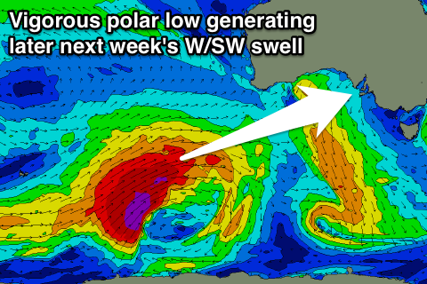
A vigorous polar low is expected to form in the Heard Island region this weekend, projecting a fetch of severe-gale to storm-force W/SW winds up more through our western and then south-western swell window.
With this we'll see a moderate to large W/SW tending SW groundswell being generated, building Thursday, peaking later in the day and then easing Friday.
4-5ft+ sets are likely off Middleton with 2ft to occasionally 3ft sets on the favourable parts of the tide along with S'ly winds Thursday and SE winds Friday, but more on this Friday. Have a great weekend.


Comments
The ol' Superbank has a few clean runners again this morning.
And a few at the Hump too.
Superbank, dream on. Most of the sand has moved north into the bay helping to create s very well defined bank on low tide at the Hump. Took the 9' roger out there yesterday but the tide was getting a bit full and I kept burying the nose on takeoff due to too many dribs sessions lately.
C'mon mate, haven't you had your irony pills today?