Excellent easing surf tomorrow, good waves next week
South Australian Forecast by Craig Brokensha (issued Wednesday 19th October)
Best Days: South Coast Thursday, Mid Coast Saturday, South Coast Sunday morning, South Coast Monday and Tuesday mornings
Recap
Onshore waves between 2-3ft yesterday across the Mid Coast, largest through the afternoon, while the South Coast saw OK waves in protected spots through the morning as the new swell started to build.
Today is the pick though with light offshore winds across both coasts, 2ft to occasionally 3ft waves on Mid Coast and 4-6ft on the South Coast. Conditions should remain good all day across both coasts as winds tend variable into the afternoon and the swell starts to ease down South.
This week and weekend (Oct 20 - 23)
This morning's large peak in SW groundswell will ease off into the afternoon and further tomorrow, dropping from 3-4ft at Middleton and 1-2ft on the Mid Coast.
Conditions will be great down South with a fresh N/NE tending N/NW breeze ahead of an approaching front and early evening W/SW change.
This change is linked to a cold front pushing up and through the Bight, with its strength being upgraded a touch since Monday.
This will produce a new W/SW swell for the Mid Coast Friday to 1-2ft, biggest through the afternoon and with onshore W/SW tending SW winds.
The South Coast will likely see an early W/NW breeze and leftover 2-3ft waves off Middleton.
The start of the weekend is looking poor down South with fresh onshore S/SE winds Saturday, spoiling a new SW swell generated by the initial stages of later Thursday's front.
The Mid Coast however should offer fun 1-2ft sets Saturday, tiny into Sunday.
A swing in winds to the E/NE Sunday morning will provide cleaner conditions across the South Coast with easing surf from 3ft off Middleton.
 Next week onwards (Oct 24 onwards)
As talked about on Monday, a couple of good pulses of groundswell are due next week across the state.
The first for Monday afternoon and Tuesday morning will be generated by a broad fetch of pre-frontal W/NW gales through our south-western swell window over the coming days.
Fun 2-3ft waves are due off Middleton Monday afternoon and Tuesday morning with light morning offshores. The Mid Coast isn't expected to see any size at all.
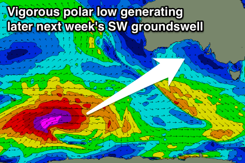
A larger SW groundswell is then due Thursday/Friday from a vigorous polar low firing up in the Heard Island region again. This swell won't be as big as today's and winds look to be from the SE, but more on this Friday.

