Easing surf, cleanest Friday, small average weekend, large swell next week
South Australian Forecast by Craig Brokensha (issued Wednesday 12th October)
Best Days: Thursday morning and Friday down South at swell magnets, Mid Coast Sunday afternoon
Recap
Lots of swell but less than ideal and gusty W'ly winds on the South Coast, while the Mid Coast dropped back from a messy 2-3ft.
A strong new S/SW groundswell arrived into the afternoon down South and this has held well into this morning with more favourable W/NW winds. Spots around Victor were great while the Mid Coast was small and OK.
This week and weekend (Oct 13 - 16)
Over the coming days the current S/SW swell will slowly ease away, with a weak front currently pushing into Tassie, just slowing this trend slightly.
Middleton should ease from 3ft tomorrow morning, down further from 2ft+ Friday morning. The Mid Coast will become tiny tomorrow and effectively flat Friday.
Conditions tomorrow will be OK but not perfect down South with a light E/NE tending NE breeze ahead of sea breezes, while Friday is the pick at swell magnets under a N/NE tending N/NW and then variable breeze.
All day and fresh offshore N/NE tending N/NW winds are due Saturday ahead of an onshore change on dark. Only a very inconsistent long-range SW groundswell is expected to be in the water though with 1-2ft sets at Middleton and 2-3ft sets Waits and Parsons.
The late W'ly change will be linked to a weakening mid-latitude frontal system pushing through the Bight.
This system will in its early stages Friday and Saturday, project a fetch of strong to gale-force W/SW winds up towards WA and through the Bight, generating a moderate sized and acute W/SW swell for Sunday afternoon and more so Monday morning.
The swell won't be ideally aimed at all for the South Coast, with no major size due at all Sunday. The Mid should build to 2ft through the afternoon, mixed in with some weak windswell, easing from 2ft+ Monday morning.
Conditions will be bumpy on the Mid but workable with a moderate W/NW tending W/SW breeze, while the South Coast will be clean in protected spots but small.
 Next week onwards (Oct 17 onwards)
Monday's peak in W/SW swell will be met with freshening W/NW winds, but Middleton inst expected offer much over 2ft with the west in the swell.
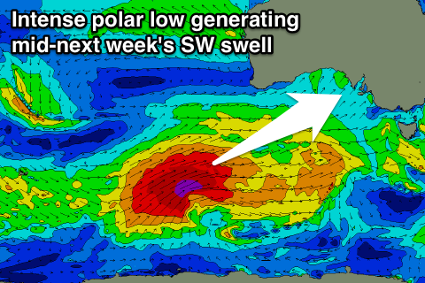
Of greater importance is a large SW groundswell mentioned in Monday's notes. This will be produced by a vigorous polar low forming east of Heard Island, generating a fetch of severe-gale W/SW winds before being projected up towards the Bight later in the weekend and early next week.
A large long-period SW groundswell is due, with some swell arriving ahead of it from pre-frontal W/NW winds. The surf should start kicking Tuesday afternoon and peak Wednesday morning with what looks to be W'ly winds, but more on this Friday.


Comments
Couple of tiny waves sneaking into the Mid this afternoon, super glassy conditions too.