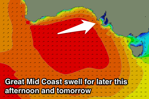
Great Mid Coast tomorrow, best down South Friday
South Australian Forecast by Craig Brokensha (issued Monday 1st August)
Best Days: Mid Coast Tuesday through Thursday, South Coast Thursday morning, Friday, Saturday afternoon, Sunday
Recap
A good fun weekend of waves across the South Coast with surf in the 3ft range off Middleton under offshores Saturday, smaller into Sunday. The Mid Coast was around the 1ft range most of the day, kicking later in the day as winds remained favourable.
Today a new W/SW groundswell was coming in around 2ft+ on the Mid with similar sets off Middleton under early favourable winds, but these have since shifted onshore. A strong new long-period W/SW groundswell is due into this afternoon (Cape du Couedic is climbing nicely) but with stronger S'ly winds. This should favour the Mid Coast for the late session though with sets to 3-4ft expected.
This week (Aug 1 - 5)
 This afternoon's large kick in W/SW groundswell impacted WA yesterday and is still in the XXL range this morning, with us due to see the Mid kicking to 3-4ft, while the South Coast should sets kicking to 4-6ft, larger at Waits and Parsons.
This swell is expected to ease through tomorrow on the Mid from the 3ft range, further from 2ft Wednesday.
The South Coast should also ease, with an afternoon increase in new long-period energy not being above what will already be in the water, easing into Wednesday.
Conditions will unfortunately be poor down South tomorrow and Wednesday but good for the Mid with a S/SE-S'ly breeze persisting all day tomorrow, similar through Wednesday.
A new reinforcing W/SW groundswell is due into Thursday morning, with it currently being generated by a pre-frontal fetch of gale to severe-gale WNW tending NW winds pushing in from the south-east Indian Ocean.
This should keep Middleton up around 3ft+ with 5ft sets at Waits and Parsons, while the Mid should see 1-2ft waves, with both coasts easing into the afternoon and further Friday.
Conditions will improve down South but still likely be a bit peaky and not totally lined up with a morning NE'ly, tending SE into the afternoon.
Friday looks the pick of the week down South with N/NE offshores and easing 2-3ft sets off Middleton.
The Mid will become tiny, fading from 1ft+ or so.
Into the weekend there's not much expected at all as a large blocking high moves in later in the week, sitting just to our east through the weekend and early next week. This will deflect any major swell generating systems away from us but keep persistent offshore N'ly winds blowing across the state.
Small pulses of inconsistent W/SW groundswell are due from fronts pushing up towards WA, the first for Saturday afternoon, easing Sunday, but we'll have another look at this Wednesday.

