Fun South Coast through to the weekend, W/SW swells for next week
South Australian Forecast by Craig Brokensha (issued Wednesday 27th July June)
Best Days: South Coast every day, Mid Coast Sunday afternoon
Recap
Plenty of swell across the Mid Coast the last couple of days with 2-3ft sets yesterday under a workable NW'ly early, strengthening through the day before shifting W'ly overnight and then lighter from the S/SW this morning with a new swell to 3ft. Winds have since strengthened again creating poor conditions.
The South Coast was great yesterday with a large new SW groundswell under offshore winds, becoming tricky into the afternoon as winds strengthened. Today the swell was down a touch but still large with strong onshore winds. Winds should swing more W'ly mid-late afternoon but tomorrow will be the day to surf.
This week and weekend (Jul 28 - 31)
Easing surf is due into tomorrow, slowed slightly by a reinforcing SW groundswell pulse from a relatively weak cold front passing under us today.
Middleton should ease from the 4ft range, larger out Waits to an easy 6ft with the Mid dropping back from 2ft. A W/NW breeze is due all day, favouring protected spots on the South Coast.
Friday should be smaller again but not dropping below 3ft at Middleton with 1-1.5ft sets on the Mid under even better NW winds.
Later Friday but more so Saturday a new S/SW groundswell is due from a strengthening mid-latitude front late in our swell window Thursday evening and Friday. A fetch of SW gales will be aimed towards Vicco and into Tassie, generating a fun S/SW groundswell to 3ft+ at Middleton and 4-5ft at Waits and Parsons.
A long-range SW groundswell will also be in the mix through the afternoon to a similar size, generated by a vigorous polar low that developed in the Heard Island region the last couple of days. The Mid Coast isn't due to see much size, easing from 1ft.
Great winds are due down South, with a fresh N'ly tending N/NW breeze, while Sunday looks funky with an early morning onshore change due to be weak enough to result in variable winds developing by dawn and remaining so into the afternoon.
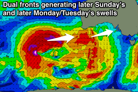
 Into the afternoon a new W/SW groundswell should be seen across both coasts, produced by a vigorous mid-latitude front pushing east from off WA, through the Bight Friday and Saturday.
The Mid Coast should see a good kick to 2ft to possibly 3ft mid-late afternoon with great conditions under those variable winds. The South Coast should just steady with the westerly nature of the swell.
Next week onwards (Aug 1 onwards)
The frontal system pushing through the Bight on Saturday was in its earlier life a strong polar frontal system in the Indian Ocean, and some less consistent swell from this is due to peak Monday morning.
Of greater importance is a larger pulse of long-period W/SW groundswell due into the afternoon and Tuesday, produced by a very strong polar front moving in and over the active sea state produce by the first storm.
A fetch of severe-gale W/SW winds will be projected through our western swell window, followed by a secondary patch fetch of gale to severe-gale SW winds.
A moderate to large long-period W/SW groundswell is due Monday afternoon back to a strong 2-3ft on the Mid, holding in the 3ft range Tuesday.
The South Coast will see less size than if this were SW energy with Middleton expected to offer inconsistent 3-5ft sets across the Middleton stretch at the peak Tuesday morning with larger 6ft+ sets at Waits and Parsons.
Conditions will become bumpy on the Mid and be best on the South Coast Monday with a strengthening N/NW tending W/NW breeze and then W/NW winds are due most of Tuesday.
Beyond the WSW groundswells we've got a strong stalling low on the cards for the middle of the week as an upper cold pool breaks off across WA and then sits across the south-east of the country. With this stormy swell is due across both coasts at some stage, but more on this Friday.

