Lots of swell for the weekend, larger and cleaner for the South Coast next week
South Australian Forecast by Craig Brokensha (issued Friday 22nd July June)
Best Days: Mid Coast Saturday afternoon, Sunday morning South Coast, Monday morning South Coast, Wednesday onwards South Coast
Recap
Pumping waves all day down south yesterday with a strong easing SW groundswell from 3-5ft off Middleton with all day offshores, while the Mid Coast was still around 1-2ft but bumpy with a N/NE wind. This wind freshened through the day deteriorating conditions further.
Today average waves were seen across the Mid with a fresh NNW'ly, while the South Coast was clean in protected spots and back to a smaller 2-3ft. This afternoon a larger stormy swell is due to build across the Mid Coast, but only just before dark, with the most size seen overnight and early tomorrow.
This weekend and next week (Jul 23 - 29)
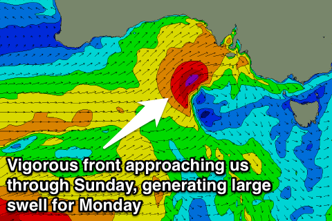
Currently a vigorous mid-latitude front is projecting a fetch of gale to severe-gale W/SW winds through the Bight, and this will produce a large mid-period W/SW swell for this evening, easing back steadily through tomorrow.
The Mid Coast is expected to ease back from the 3ft+ range along with strong but rapidly easing SW tending W'ly winds. Therefore the mid-late afternoon should be OK with lumpy smaller surf.
This swell will be really west for the South Coast and isn't due to offer much size at all.
A better aligned fetch of strong to gale-force S/SW winds projecting north up and into us this evening and tomorrow morning should generate a new S/SW groundswell for the afternoon, easing Sunday.
A kick to 3-4ft across Middleton is due later in the day, much smaller earlier in the day, easing Sunday from a similar size.
Conditions will only improve late down South Sat, with Sunday being better under fresh N'ly tending variable ahead of a mid-late afternoon W'ly change.
This W'ly change will be linked to another strong mid-latitude low pushing up and across the state, but this one will be slightly more south in latitude, resulting in a lot more size for the South Coast.
 A fetch of gale to severe-gale W/SW winds will be projected into us Sunday afternoon and evening, with a late building windswell on the Mid, with groundswell peaking Monday morning to 3ft.
The South Coast should see solid 5-6ft waves across Middleton with much larger waves out at Waits Monday morning.
Conditions will be best in protected locations with a fresh and gusty W/NW'ly persisting most of the day, swinging W/SW later in the day.
Now, as touched on last update, an elongated node of the Long Wave Trough is forecast to spread out across our swell window through next week.
This will direct strong front after front up from the polar shelf towards us, the first forming this evening in the Heard Island region. This will generate a fetch of severe-gale to storm-force W/SW winds before projecting north-east towards us while weakening a touch but broadening in scope Monday.
The front will push across us Monday, with a large S/SW groundswell due to build through the day Tuesday, peaking overnight and easing Wednesday.
A secondary strong frontal system generating pre-frontal W/NW gales and post-frontal severe-gale to storm-force W/SW winds should produce another large S/SW groundswell for Thursday afternoon and Friday morning with favourableW/NW winds, more N'ly into the end of the week.
We'll look at this more on Monday, have a great weekend!


Comments
Looking rather fun at Middleton this morning!
The cam takes away that lovely poo brown colour. Sepia Suicides Shot would look awesome.