Fun waves across both coasts, best Thursday down South
South Australian Forecast by Craig Brokensha (issued Monday 18th July June)
Best Days: Both coasts tomorrow and Wednesday morning, South Coast Thursday and Friday morning, keen surfers Mid Coast Saturday, South Coast Sunday
Recap
Great waves all weekend down South with an easing S/SW groundswell Saturday from the 3ft range off Middleton along with offshore winds. Sunday was a bit smaller and better off around Waits and Parsons.
The Mid Coast was tiny Saturday with a touch more size to 1-1.5ft Sunday with increasing N'ly winds.
Today a W/SW groundswell has provided better 1-2ft sets across the Mid but with a N'ly wind, while the South Coast was clean but small and leftover 2ft sets max off Middleton.
This week (Jul 19 - 22)
We've got some good fun days on the cards for the South Coast over the coming week, while the Mid should also see small fun sets.
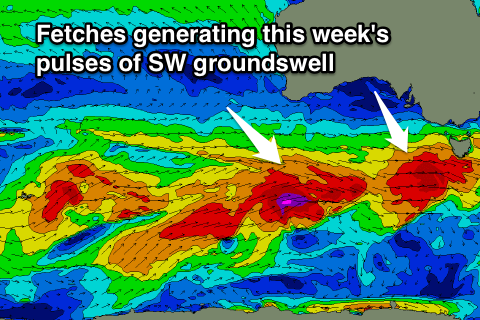
Through tomorrow a mix of long-range W/SW groundswell from the Indian Ocean and closer-range SW swell is due across both coasts.
The long-range energy should be present from dawn with infrequent 1-2ft sets on the Mid and 2ft to occasionally 3ft sets at Middleton on the South Coast with larger 4ft waves at Waits and Parsons.
 Into the afternoon a new consistent SW groundswell is due, produced by a strengthening mid-latitude front that's currently moving in from the west under the Bight. A fetch of W/SW gales should see the surf kick to 3-4ft by dark at Middleton with 5ft+ waves at Waits and Parsons while the Mid is due to hang around 1-2ft.
Similar sized sets are due into Wednesday, and on dark, but more so Thursday a slightly stronger pulse of SW groundswell is due across the state.
This will be generated by a secondary fetch of severe-gale to sub-storm-force W/SW winds moving in on the back of the mid-latitude front generating tomorrow's swell.
Middleton should see better 3-5ft sets Thursday morning with 6ft+ sets at Waits and Parsons. The Mid may see 1-2ft sets continuing, easing through the day, along with the South Coast.
Variable tending light offshore winds are due tomorrow, favouring both coasts, with weak onshores into the afternoon.
Wednesday won't be as favourable down South with an E/NE'ly tending variable breeze, but Thursday looks great with N/NW winds all day.
Into the end of the week the SW swell will continue to ease Friday morning under a W/NW breeze that will be strong early, ease through the day and then strengthen late again in the day. With this any W/NW windswell due across the Mid will ebb and pulse, only coming in around 1-1.5ft or so at this stage.
This weekend onwards (Jul 23 onwards)
A multi-staged mid-latitude low moving across us Friday and Saturday will generate some W/SW swell for the Mid Saturday as a fetch of W'ly gales push through the Bight Friday and across Adelaide into the evening.
This should produce 2-3ft of W/SW swell for the Mid which will ease through the day under easing W/SW winds.
The South Coast should see some mid-period SW swell building from a weaker fetch of strong to gale-force W/SW winds passing under us Friday night and early Saturday.
I can't see any major size off these developments above 3ft+ across Middleton and 5ft at Waits and Parsons along with W/NW tending W/SW winds.
The swell will then ease Sunday with better morning NW winds. We'll have another look at this Wednesday though as the models are divergent on the structure of this low.


Comments
Fun clean waves on the Mid Coast...
And stacks of clean lines at Victor too!