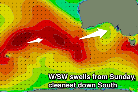
Persistent W/SW swells with north-west winds
South Australian Forecast by Craig Brokensha (issued Wednesday 13th July June)
Best Days: South Coast all weekend, Mid Coast Sunday morning, South Coast most of next week, Mid Coast Tuesday
Recap
Great waves around Victor yesterday with a large easing S/SW groundswell under offshore winds, while today the surf was still strong but more back to the 3-5ft range under a light offshore. The Mid eased back from an average 1-2ft, tiny and back to 1ft today.
This weekend (Jul 16 - 17)
Conditions are looking excellent down South all weekend with a light offshore tending variable wind tomorrow and fresher N/NE tending N/NW winds Sunday.
Size wise, we'll continue to see today's S/SW groundswell easing, backing off quickly from the 3ft range at Middleton around dawn and 4ft at Waits and Parsons.
The Mid will be tiny but later in the day a good pulse of new W/SW groundswell is due, generated by a flurry of strong frontal activity to the west and south of WA.
Two pulses are due, the first for tomorrow afternoon to 1-1.5ft while Sunday should see a better 1-2ft of swell across the Mid.
The South Coast isn't due to see much of an increase later tomorrow while Sunday should see 2-3ft sets along the Middleton stretch with the most size from Day St onwards, with larger 4ft+ waves out at Waits and Parsons.
Next week onwards (Jul 18 onwards)
 Moderate pulses of W/SW groundswell will continue into early next week from back to back and strong polar fronts firing up west-southwest of WA.
An easing trend is expected into Monday morning down South ahead of a new pulse into the afternoon and further kick Tuesday. Middleton should hover between 2-3ft with 4ft+ waves at Waits and Parsons Monday afternoon and Tuesday morning, kicking a bit further into the afternoon.
The Mid is also expected to hover around 1-2ft for the most part, more consistent into later Monday and Tuesday to 2ft.
NW winds will continue Monday favouring the South Coast with more variable and locally offshore breezes Tuesday.
Into Wednesday and more so Thursday a good pulse of moderate to large sized SW groundswell is on the cards.
A strong polar low firing up east of Heard Island will push east-northeast towards us from Sunday through early next week, generating a fetch of gale to severe-gale W/SW winds.
The swell from this system will be a great long-period SW number and should peak Thursday to 4-5ft at Middleton while the Mid will be small to tiny. Winds are a little funky but could be offshore, we'll have another look at this Monday though. Have a great weekend!

