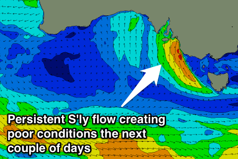
Average couple of days, improving from Thursday
South Australian Forecast by Craig Brokensha (issued Monday 4th July June)
Best Days: Mid Coast Tuesday for keen surfers, South Coast Thursday and Friday mornings, South Coast Saturday, protected spots Sunday
Recap
Great waves down South all weekend with the most size Saturday and best conditions Sunday. The Mid Coast hovered between 1-2ft but conditions were average for the most part.
This morning a new long-range SW groundswell has filled in with good clean 3-4ft sets off Middleton and more size out at Waits and Parsons under offshore winds. The Mid continued around 1-2ft but N'ly winds continued to create bumpy conditions. An onshore S'ly change is moving in from the west now, and this will write off the surf down South but create better conditions for the Mid.
This week and weekend (Jul 5 - 10)
Today's long-range SW groundswell is due to start to ease through tomorrow and the Mid will be the best bet with fading and bumpy 1-2ft sets under gusty S/SW winds. The South Coast will be a complete mess.
Poor winds will continue into Wednesday as a deepening surface trough and low move east before stalling off the southern NSW coast,
 An easing mix of S'ly windswell and groundswell will be seen down South with bumpy tiny waves on the Mid.
Into the end of the week, two successive pulses of S/SW groundswell are due for both Thursday and Friday respectively.
The first pulse has and is still being generated by a distant storm and severe-gale to storm-force fetch of W/NW gales along the polar shelf.
This first swell should arrive overnight Wednesday and peak Thursday to a strong but inconsistent 3-4ft at Middleton and 6ft at Waits and Parsons (under model forecasts). The Mid may see 1-1.5ft sets if we're lucky.
A secondary more consistent and more S'ly swell is due Friday, produced by a secondary late forming polar low in our swell window, again producing gale to severe-gale W'ly winds.
This swell is due to arrive mid-late morning Friday, steadying the easing trend from Thursday's swell with 3ft+ sets across Middleton all day and 5ft waves at Waits and Parsons. Only a tiny 1ft wave if that is due on the Mid.
Conditions should improve from Thursday as the low off the East Coast starts weakening, resulting in variable tending E/NE breezes (S/SE into the afternoon), while Friday looks to play out similar.
Into the weekend conditions will become super clean Saturday and then likely blown out Sunday with easing surf and freshening N'ly winds on the former and strong N/NW tending NW winds Sunday. This will kick up a building windswell across the Mid Coast to a choppy and solid 3ft or so. The South Coast will see a new long-period W/SW groundswell, generated from an unfavourably tracking and short-lived but intense low forming south of WA. This should keep 2ft+ waves hitting Middleton with 4ft sets at Waits but under those tricky strong offshores.
Longer term a large messy S/SW groundswell is due Tuesday/Wednesday as a deep mid-latitude low moving in and across us Monday combines with a strong polar outbreak. More on this Wednesday though.

