Great few days for the South Coast
South Australian Forecast by Craig Brokensha (issued Friday 1st July June)
Best Days: South Coast Saturday, Sunday and Monday, Mid Coast keen surfers Monday and then early Tuesday
Recap
A building storm swell across the Mid Coast yesterday, reaching 3ft or so into the afternoon, while the South Coast also kicked to a similar size at Middleton with poor onshore winds.
This morning cleaner conditions were seen across both coasts with a variable breeze on the Mid and leftover 2ft sets, while the South Coast was a good 3-5ft and improving with a light to moderate W/NW'ly.
This weekend and next week (Jul 2 - 8)
The weekend is looking great for the South Coast with moderate amounts of swell and offshore winds.
Today a mix of short-range swell from yesterday's front and longer-range SW groundswell are breaking across the coast, and these will ease tomorrow, only to be replaced by a new reinforcing SW groundswell. This was generated by a broad pre-frontal fetch of gale to severe-gale W/NW winds under the country and should keep good 3-4ft sets hitting Middleton tomorrow, with 6ft waves at Waits and Parsons easing back from 3ft+ and 5-6ft respectively Sunday.
The Mid's only expected to be around 1-2ft on the favourable parts of the tide.
W/NW winds will persist all day tomorrow, with better NW offshores Sunday.
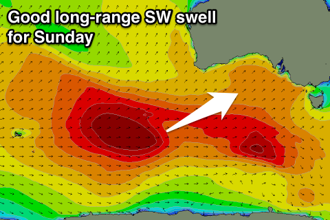
 Our strong long-range SW groundswell for Monday is still on track with a vigorous polar low firing up south-east of South Africa, traversing across the Heard Island region before weakening south-west of WA overnight.
This swell will be inconsistent but strong with solid 3-4ft+ sets due across Middleton and 6ft waves at Waits and Parsons, while the Mid should see 2ft+ sets on the favourable parts of the tide.
Conditions are looking better for Monday now as a deepening surface trough stalls to our west resulting in NW offshores most of the day, tending S'ly late in the day as the trough and developing low drifts east.
Winds for Tuesday morning are still a little tricky but onshore S/SE winds are more than likely to continued with only an outside chance for an early variable breeze. The groundswell will be easing, replaced by a building S'ly windswell.
Longer term a good new long-range SW groundswell with offshore N/NE winds is likely, but more on this Monday. Have a great weekend!

