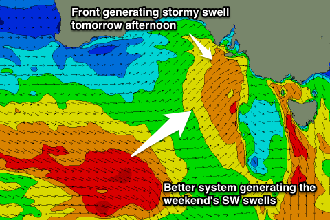
Cold stormy end to the week, better weekend
South Australian Forecast by Craig Brokensha (issued Wednesday 29th June)
Best Days: Stormy Mid waves tomorrow afternoon, South Coast Friday through Sunday, Mid Coast Monday
Recap
Plenty of swell to 2ft across the Mid Coast but with less than ideal winds from the northern quadrant. Better surf down South with offshores and moderate amounts of swell. Today a new SW groundswell has kept the surf up across both coasts, best down South with strengthening offshores.
This week and weekend (Jun 30 – Jul 3)
Short summary today as I'm not feeling the best.
 A low point in swell activity and a gusty NW wind will limit surfing options to Middleton early tomorrow before a strong SW change moves through during the mid-late morning.
This will kick up a stormy increase in swell across both coasts, reaching 3ft+ across the Mid and a similar size at Middleton with more size at Waits and Parsons.
Into Friday much better conditions are due across the South Coast as winds tend W/NW and a stronger groundswell fills in, mixed in with the windswell from Thursday's change. Middleton should see 3-5ft sets, while the Mid is expected to ease from 2-3ft.
The weekend is looking even better with offshores both Saturday and Sunday down South along with moderate amounts of groundswell.
The groundswell will be generated by broad pre-frontal fetches of W/NW gales moving under the country the coming days and W/NW-NW winds will favour Middleton Saturday, with more NW winds Sunday. Saturday will be biggest and to 3-4ft off Middleton, with 5-6ft sets at Waits and Parsons, easing back a touch into Sunday. The Mid should see 2ft sets Saturday, back to 1-2ft Sunday.
Longer term a good long-range SW groundswell is due Monday from a strong and long-lived polar low firing up in the Heard Island region. We're probably looking at inconsistent 3-5ft sets at Middleton and 2ft+ waves on the Mid as a S/SE change moves through. We'll have a closer look at this Friday.

