Lots of swell to come, pumping and clean on the weekend
South Australian Forecast by Craig Brokensha (issued Wednesday 22nd June)
Best Days: Protected locations South Coast tomorrow afternoon, stormy haunts Friday on the Mid, both coasts Saturday, South Coast Sunday and Monday
Recap
A tiny weak N'ly windswell was seen across the Mid Coast yesterday, while the South Coast was much better and clean with fun small amounts of swell, best out at Waits and Parsons.
Today the short-range swell from the front pushing across us yesterday afternoon and evening has come in a bit better than expected across the South Coast with workable 3-4ft waves off Middleton and around town under a W/NW breeze, while the Mid Coast was an average 2ft. The swell should ease through the day as conditions continue to improve down South as winds tend more NW.
This week and weekend (Jun 23 - 26)
We've got lots of tricky pulses of swell due over the coming period and generally favourable winds for the South Coast.
A low point in swell is due tomorrow morning as today's pulse eases off through the night.
Through the day tomorrow a mix of long-range SW groundswell and short-range S/SW swell are due to build into the afternoon. The long-range energy was produced by a vigorous polar low firing up over the weekend, and this system has since weakened last night.
The swell from this system should build to a good 3-4ft at Middleton by dark, with the Mid Coast kicking to 2ft but more so windswell. A peak is due Friday morning with 3-5ft sets off Middleton and an easy 6ft at Waits and Parsons.
A smaller S/SW swell will also kick later Thursday, produced by a tight and intense but fast tracking low under us today. The swell from this low will be smaller than the existing SW groundswell.
Also on Friday a new stormy SW swell will be in the mix, produced by a strengthening cold front projecting into us Thursday evening and through Friday morning.
This should kick up larger amounts of consistent SW swell for the South Coast reaching 4-5ft at Middleton and 6-8ft at Waits and Parsons while the Mid should see stormy surf in the 3ft+ range.
Winds tomorrow are due to be fresh to strong from the NW, swinging W'ly into the afternoon, while Friday looks poor with a strong SW'ly (slim chance for an early W'ly around Victor).
Easing surf is due through the weekend as the frontal activity moves off quickly to the east, but a reinforcing SW swell for Saturday morning will slow the easing trend.
Conditions are looking great across the South Coast and also Mid early Saturday with a variable tending N/NW breeze (likely variable all day down South).
Middleton is due to ease from 3-5ft with larger sets at Waits and Parsons, while the Mid is expected to drop from a good 2-3ft.
Sunday will be smaller again and great all day with N/NE tending N/NW breeze.
Next week onwards (Jun 27 onwards)
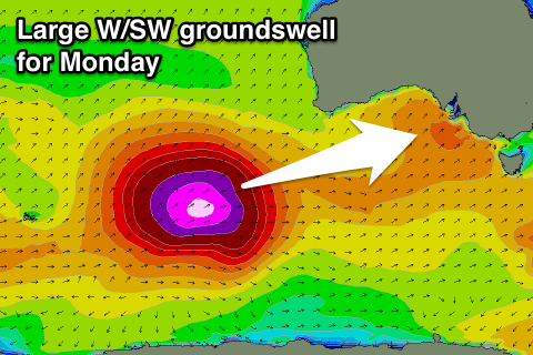
 Monday afternoon's large W/SW groundswell is still on track, but the timing has been pushed back a touch, with it really pulsing mid-late morning.
Currently a vigorous polar low is forming in the Heard Island region, and we'll see this low project a slow moving fetch of severe-gale to storm-force SW winds in a captured fetch motion towards Western Australia. The low will then push through the Bight while weakening, continuing on and into us later Sunday.
A large W/SW groundswell will result, arriving through Monday, peaking through the afternoon to 6ft+ across Middleton and 8-10ft at Waits and Parsons with strong 3-4ft sets on the Mid. Winds are looking best on the South Coast with a W/NW tending W/SW breeze, but we'll review this Friday.


Comments
The Bay looking super fun this afternoon..
Westerlies the devil wind
Personally I think Easterlies are the devil wind Barley ;) ha ha