Less than ideal weekend, better Monday
South Australian Forecast by Craig Brokensha (issued Friday 17th June)
Best Days: Tiny waves on the Mid Coast Saturday and Sunday for beginners, Sunday morning South Coast, Monday down South
Recap
Great waves all day yesterday across the South Coast with moderate amounts of clean swell through the morning, kicking stronger from the mid-afternoon onwards with the arrival of a long-period S/SW groundswell. Winds remained favourable all day create excellent surf into the evening.
This morning an onshore change was delayed a couple of hours with clean conditions and 3-5ft surf, but it's a mess now with gutsy S'ly winds moving in just before 8am. The Mid Coast saw a touch more size to 1-1.5ft today but mainly for beginners.
This weekend and next week (Jun 18 - 24)
We've got two good pulses of reinforcing groundswell due over the weekend, the first from the SW tomorrow morning ahead of a larger kick later in the day from the S/SW, easing Sunday.
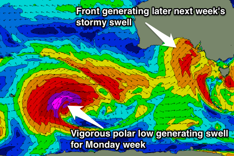
These swells have been generated by back to back polar frontal systems moving through our swell window under the country, but the second system is a touch stronger and broader than expected, producing a larger S/SW groundswell pulse later tomorrow and Sunday morning.
We should see Middleton kick to 3-5ft again later tomorrow and ease from a similar size Sunday morning, but a SE tending E/SE breeze will create less then favourable conditions Saturday.
Sunday should be a touch better with a variable tending E'ly wind, tending S'ly through the day.
The Mid Coast should see 1ft waves continue tomorrow, reaching 1.5ft through the mid-late afternoon, easing from 1ft+ Sunday.
Monday is the pick of the swell as it eases from 3ft+ at Middleton and 5ft at Waits and Parsons under an increasing N/NW offshore.
The surf will continue to ease and bottom out through Tuesday and an early W/NW'ly will give way to a W/SW change. This will kick up a late increase in windswell across both coasts, easing back slowly Wednesday with a mix of stronger small SW groundswell.
 The Mid should see stormy 2-3ft waves through Tuesday from the front (easing from 2ft Wednesday), with Middleton only kicking to a similar 2-3ft later in the day, easing back from 3ft Wednesday morning with larger 4-5ft sets at Waits and Parsons.
Another approaching front will swing winds around to the north quickly Wednesday creating clean conditions across both coasts all day.
This front moving in from the west will be stronger and larger in scope, generating a larger increase in short-range W/SW and S/SW swell across both coasts into the end of the week.
The W/SW swell will be generated as the front moves east through the Bight, kicking later Thursday and peaking Friday to 3ft+ on the Mid. The S/SW swell will then be generated by trailing fetches of S/SW gales pushing in on the back of the front and will kick up solid waves across the South Coast Friday likely to 4-5ft+ across Middleton but with gale-force onshore winds. We'll take a closer look at this Monday, have a great weekend!

