Great Thursday, average until Sunday
South Australian Forecast by Craig Brokensha (issued Friday 10th June)
Best Days: Thursday down South, Sunday morning down South, Mid Coast for beginners over the weekend
Recap
Good clean fun waves around 2-3ft yesterday morning across the South Coast, with a new swell building later into the afternoon with weak sea breezes. This swell has held well into this morning with a bit of morning sickness early but this has ironed out. Middleton is a good 3-4ft with similar sets around Victor while Waits and Parsons are on the bigger side. Conditions should remain clean all day as winds hold from the NE and the swell eases a touch.
The Mid Coast has been around the tiny 0.5-1ft range the last two days, perfect for beginners.
This week and weekend (Jun 16 - 19)
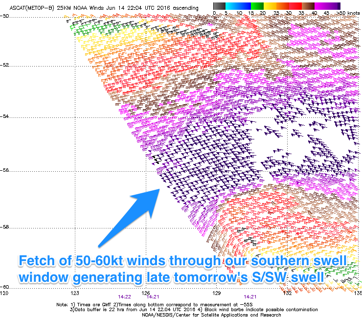
Today's swell will continue to ease through tomorrow before a strong and powerful S/SW groundswell arrives through the afternoon.
 Satellite observations confirm a fetch of storm-force 50-6kt W'ly winds generated late through our southern swell window, with Middleton due to kick to at least 4ft before dark and 5ft+ at Waits and Parsons ahead of a peak overnight. Conditions look excellent all day with a N/NE tending N/NW wind.
We'll see the swell ease back through Friday but a fresh onshore change is due before dawn, creating poor conditions. This change will create cleaner conditions on the Mid but the S'ly swell isn't ideal with tiny 0.5ft sets at best.
Into the weekend we'll see two seperate pulses of reinforcing SW groundswell from a couple of back to back polar fronts firing up under WA and towards Victoria over the coming days.
The first pulse is due Saturday morning with a secondary pulse for the mid-late afternoon, easing back through Sunday and further Monday.
Middleton should hang around 3-4ft most of the weekend, with the odd bigger set late Saturday and early Sunday, while Waits and Parsons will be maxing and around the 6ft range.
The Mid Coast should see better size to 1ft+ through the favourable parts of the tide all weekend with the better alined swells.
Conditions are looking less than perfect though down South (good on the Mid) with a E/SE tending S/SE breeze Saturday and then better N/NE offshores Sunday morning, more variable into the afternoon.
Next week onwards (Jun 20 onwards)
We're looking at a slow start to early next week but some better activity is on the cards near the end, but this may be with onshore winds. Check back here Friday for more on this.


Comments
Coupla nice sidewinders at Knights.
Those lines were groomed ok today ben