Great week for the South Coast
South Australian Forecast by Craig Brokensha (issued Monday 13th June)
Best Days: Tuesday through Thursday down South, Saturday and Sunday morning
Recap
A morning W'ly and building swell provided fun waves in protected spots across the South Coast Saturday before an onshore change moved through. The Mid was a bumpy and tiny 1-1.5ft.
Sunday was great down South with a much cleaner swell easing from 3-5ft across Middleton and Victor, with larger sets at Waits and Parsons. Offshore winds held most of the day before tending E'ly mid-afternoon.
Today the swell was back more to the 3ft range across Middleton as offshores continued, with tiny 0.5-1ft waves on the Mid.
This week (Jun 14- 17)
Our great outlook for the week is still on track with lots of swell and offshores due from tomorrow through until an onshore change moves through Friday.
The weekend's swell is expected to continue to ease into this afternoon, but during tomorrow a strong new S/SW groundswell will fill in down South, with a secondary pulse for early Wednesday morning.
These swells have been produced by flurries of pre-frontal severe-gale W/NW winds through our southern swell window the last few days, with the activity now passing under Tasmania.
Middleton should build to a strong 3-5ft through the day, with larger 6ft sets at Waits and Parsons into the afternoon, easing from a similar size Wednesday morning.
The southerly direction isn't ideal at all for the Mid, with tiny 0.5-1ft sets max expected.
Conditions will be good most of tomorrow with an offshore N'ly tending variable breeze, and then persistent N/NE winds Wednesday.
Thursday will see the swell continue to ease but not below 3ft at Middleton and 4-5ft at Waits and Parsons ahead of a late and strong new increase in S/SW swell.
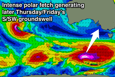
 This swell will be generated by a tight and intense polar front developing south-west of WA this afternoon with a pre-frontal fetch of severe-gale W/NW winds setting up an active sea state for stronger storm-force W'ly winds to move over.
A strong long-period S/SW groundswell will result, with it due to fill in through the afternoon and kick strongly late in the day to at least 4ft across Middleton and 5ft+ at Waits and Parsons. A peak is due overnight with easing surf from a similar size range Friday morning.
Thursday will be the day to surf with offshore N/NE tending N/NW winds, while an onshore change is due around dawn Friday creating poor conditions. The Mid won't be any better with tiny 0.5ft sets.
This weekend onwards (Jun 18 onwards)
Into the weekend and early next week, additional pulses of SW groundswell are due across the state as the frontal activity to our south-west continues. Winds are the only real issue with an E/NE Saturday morning and more variable breezes Sunday morning, but the the amount of swell there'll be plenty of options. We'll take a closer look at this Wednesday.

