Large surf for the weekend, cleanest Sunday
South Australian Forecast (issued Friday 1st April)
Best Days: Mid Coast later Saturday, both coasts Sunday and Monday morning, Tuesday down South
Recap
Great surf across the exposed beaches down South yesterday with clean conditions and a fun swell, while today, a strong new S/SW groundswell has peaked with inconsistent but strong 3-5ft sets around Middleton under perfect offshore wind. The swell should ease through the day as winds hold from the NW.
The Mid Coast has been tiny, with a weak N'ly windswell this morning.
This weekend and next week (Apr 2 - 9)
South Coast: There's been no real change to the weekend's forecast, besides a slight upgrade in the size due Sunday morning across the South Coast.
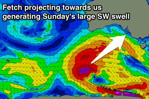
A vigorous and back to back frontal progression has and is still taking place through our swell window, with an initial front projecting towards WA and the Bight setting in motion a large W/SW groundswell that's due to fill in through tomorrow and peak through the afternoon.
A larger SW groundswell will be seen Sunday morning though, from a secondary front that's currently south-west of us, projecting a fetch of severe-gale W/SW winds up through our south-western swell window.
 We should see Middleton building from 3-5ft tomorrow morning more to 4-6ft into the afternoon/evening, with Sunday's swell now looking to peak to a large 6ft+ with 8ft+ sets at Waits and Parsons, easing through the afternoon.
Winds tomorrow will be average with a fresh SW tending S'ly wind, but Sunday looks to see cleaner but not perfectly aligned conditions with a light E/NE offshore ahead of afternoon S/SE sea breezes.
The surf will ease back through Monday and Tuesday, from 3-5ft at Middleton Monday morning, down from 3ft Tuesday morning.
Conditions will be much better with offshore N/NE winds Monday morning and N/NW winds Tuesday ahead of an afternoon W/SW change.
Mid Coast: The W/SW groundswell tomorrow should build strongly through the day from 1-2ft through the morning to 2-3ft later in the day as winds tend S/SE, creating cleaner conditions.
Sunday should see the swell ease back from 2-3ft with offshore E'ly winds, down further from 1-2ft Monday morning.
Longer term some moderate SW swell is due Wednesday/Thursday but with average winds, we'll have a closer look at this Monday though. Have a great weekend!


Comments
The Mid looking the goods this morning!
Still pumping on the Mid.
Decent readings on Cape De Couedic buoy on weekend
Barley your secret left must have been on ?