Plenty of swell to come but with less than ideal winds
South Australian Forecast (issued Wednesday 23rd March)
Best Days: Keen surfers Saturday and Sunday mornings down South, tiny peelers on the Mid, Monday morning down South, Wednesday down South
Recap
Tiny waves on the Mid to 0.5ft, pulsing to 1ft through the afternoon but with sea breezes. The South Coast saw a strong S/SW groundswell fill in with offshore winds, providing great waves across Middleton and around Chiton before sea breezes kicked in.
Today the swell had dropped back a bit and early light winds have given into an onshore change, creating poor conditions.
This week and weekend (Mar 24 - 27)
South Coast: The first in a series of S/SW groundswells due across the state is expected to fill in tomorrow, building towards a peak into the evening ahead of a drop Friday.
The front generating this swell is currently to our south-west and we should see Middleton building to 3-4ft, with 5ft sets at Waits and Parsons, easing from 3ft+ and 4-5ft respectively Friday morning.
Conditions will be less than ideal with a light to moderate E/SE breeze tomorrow ahead of S/SE sea breezes, while less favourable S/SE winds are due Friday.
Into Saturday two stronger pulses of S/SW groundswell are due, the first for the morning from a pre-frontal fetch of W/NW gales, with a stronger pulse into the afternoon from a post-frontal fetch of W/SW gales.
Saturday morning's should provide 3-4ft sets at Middleton with larger 5ft+ sets at Waits and Parsons, building more to 3-5ft and 5-6ft respectively into the late afternoon.
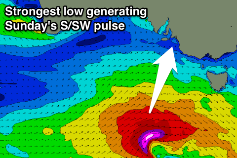
 The largest S/SW groundswell will be generated by a strengthening mid-latitude racing in from the west during Friday and Saturday, aiming a fetch of severe-gale to possibly storm-force SW winds through our southern swell window.
A longer-period and moderate to large S/SW groundswell should result, peaking Sunday morning to a good 4-5ft at Middleton and 6ft+ at Waits and Parsons, easing a touch through the afternoon and further into Monday.
Conditions are looking still dicey both days over the weekend with light W'ly tending S/SW breeze Saturday and then SE winds through Sunday morning.
Mid Coast: No major size is due off tomorrow afternoon's and Friday's swell pulse over 1ft+, while the SW groundswells on Saturday and Sunday morning should provide 1-1.5ft sets on the favourable parts of the tide, with clean conditions each morning.
Next week onwards (Mar 28 onwards)
A fun reinforcing S/SW groundswell is due Tuesday morning from the final frontal system in the progression responsible for the coming swell activity, but winds again look to linger from the SE.
Better offshore winds are due Wednesday as the swell eases.
Longer term there's strong agreement regarding the formation of a broad, vigorous and expansive polar low under WA early next week, generating some large swell for later next week, but we'll have a closer look at this on Friday.

