Great Tuesday down South
South Australian Forecast (issued Friday 18th March)
Best Days: Mid Coast tomorrow, South Coast Sunday and Monday mornings, Tuesday, Wednesday
Recap
Great conditions across the South Coast again most of yesterday with a fun swell and straight offshore winds ahead of a mid-afternoon onshore change.
This morning a stronger onshore change moved through, whipping up a stormy 2ft of windswell across the Mid Coast, with poor onshore messy waves down South.
This weekend (Mar 19 - 20)
South Coast: Today's onshore change is linked to the first of two back to back fronts pushing through our swell window, generating two pulses of SW groundswell for tomorrow.
The biggest is due into the afternoon, with Middleton expected to reach 3ft+, with 4-5ft sets at Waits and Parsons, easing back through Sunday from 3ft and 4-5ft respectively.
Conditions are looking average now tomorrow morning with a SW tending S/SE breeze. There's the outside chance for a lighter W'ly early, but it's not worth the drive from Adelaide.
Sunday will be cleaner with a morning E/NE-NE offshore ahead of S/SE sea breezes.
Mid Coast: Today's stormy swell will ease into tomorrow, with the SW groundswell offering 1ft to occasionally 2ft sets with workable light S'ly winds. Sunday is due to be tiny but clean.
Next week onwards (Mar 21 onwards)
South Coast: The surf should continue to ease through Monday across the South Coast with light E/NE winds again, favouring Goolwa and Parsons over Middleton and Waits.
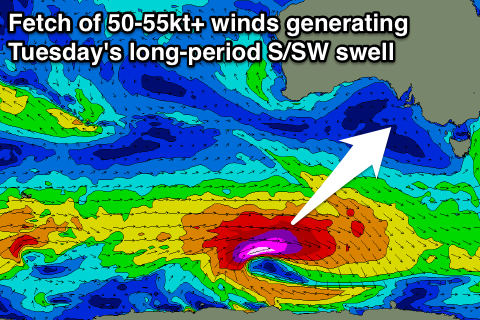
 Our strong long-period S/SW groundswell for Tuesday is still on track, with a slight upgrade in the size expected.
A vigorous polar low will now be longer-lived, with a fetch of severe-gale to storm-force W/SW winds being generated through our swell window all tomorrow and into Sunday morning.
A good S/SW groundswell will spread up radially into us, peaking Tuesday to a strong 3-4ft+ across Middleton and 5-6ft at Waits and Parsons through the morning, tailing off into the afternoon and more noticeably Wednesday before bottoming out Thursday morning.
Conditions are looking excellent Tuesday with a fresh N/NE offshore, tending variable into the afternoon and then similar but weaker winds Wednesday.
Mid Coast: No significant size is due off the S/SW groundswell with 0.5-1ft sets likely Tuesday, tiny to flat into Wednesday and Thursday.
Longer term a stronger polar frontal progression/low is forecast to produce a moderate to large sized SW groundswell for later Friday and Saturday, but we'll have another look at this Monday. Have a great weekend!

