Fun easing surf tomorrow, average until the weekend
South Australian Forecast (issued Wednesday 16th March)
Best Days: Thursday, Saturday morning, Sunday morning, Monday morning, Tuesday morning
Recap
The Mid Coast didn't really reach that surfable 1-2ft range yesterday morning with tiny 1-1.5ft sets across swell magnets under a fresh offshore wind.
The South Coast provided plenty of size but less than ideal conditions with the cross-shore breeze.
This morning was much better with a fun easing swell across the South Coast from 2-3ft at Middleton, with better options out at Waits and Parsons under a straight offshore wind.
This week and weekend (Mar 17 - 20)
South Coast: Tomorrow morning will be super clean again but with easing amounts of swell, best at Waits and Parsons with 3ft sets, while Middleton will only be around an easing 2ft.
Make the most of tomorrow as Friday will be poor with a building mix of average quality swells and a fresh to strong onshore SW wind.
This change will be linked to a couple of relatively weak polar fronts moving in from the west over the coming days, producing two separate pulses of SW swell.
The strongest pulse is due through Saturday, peaking through the middle of the day/afternoon with good 3ft+ sets across Middleton and 4-5ft at Waits and Parsons.
Conditions will be workable with a light E/SE tending E/NE wind ahead of afternoon sea breezes, while Sunday looks best with a morning NE'ly ahead of afternoon sea breezes.
Mid Coast: Tiny surf will continue tomorrow, with a slight increase in SW windswell Friday to 1-1.5ft.
The SW swell should provide 1ft to occasionally 2ft sets Saturday before fading through Sunday.
Next week onwards (Mar 21 onwards)
South Coast: Monday morning should continue to provide fun amounts of swell, easing through the day under morning E/NE winds. Parsons would be the pick.
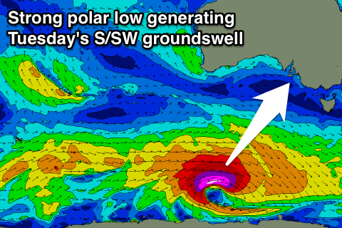
 Into Tuesday a good new S/SW groundswell is due, generated by a vigorous polar low firing up south of the country during the weekend. A fetch of severe-gale to storm-force W'ly winds will be generated through our southern swell window, with a peak due through the middle of the day.
Strong 3-4ft sets are due across Middleton, with larger 5ft+ bombs at Waits and Parsons under morning offshore winds, ahead of a S'ly change. The Mid won't see any decent size at all.
This change will leave S/SE winds through Wednesday and Thursday as new levels of S/SW groundswell start to fill in. The size, timing and amount of swell due into the Easter Long Weekend are still uncertain, so check back here Friday for the latest update.

