Fun South Coast from Sunday, larger swell later next week/Saturday
South Australian Forecast (issued Friday 19th February)
Best Days: South Coast Sunday, Monday, Tuesday and early Wednesday mornings
Recap
Tiny waves across the Mid Coast yesterday and today, while light winds each morning down South and fun amounts of swell (best at exposed breaks) have kept the South Coast decent.
This weekend (Feb 20 - 21)
South Coast: A fresh pulse of S/SW groundswell is due to fill in across the South Coast tomorrow from a strengthening front currently pushing into Tasmania.
This should kick Middleton to a good 3ft, with 4ft+ sets at Waits and Parsons but conditions will be poor with a moderate to fresh SE tending E/SE wind through the morning ahead of sea breezes.
Sunday is much better with easing levels of S/SW swell from 2-3ft at Middleton and 4ft at Waits and Parsons under morning N/NE offshores.
Mid Coast: Tiny 0.5ft waves are due all weekend down South, but even this will be too tiny for most beginners. Head South Sunday instead for a wave.
Next week onwards (Feb 22 onwards)
South Coast: Small surf is due into Monday with variable winds, likely swinging offshore through the morning creating clean conditions. Small leftover 2ft waves are due across Middleton, more in the 3ft range further afield.
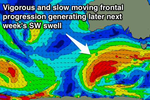
Later in the day and more so Tuesday a new SW groundswell is due ahead of a better pulse later Tuesday and Wednesday morning. These will be generated by firstly a pre-frontal W/NW fetch during the coming days and then better aligned and tracking polar front closely behind.
The first increase should provide 2-3ft sets across Middleton and 4ft waves at Waits and Parsons with more size Wednesday morning to 3ft and 4-5ft respectively.
Tuesday morning is looking clean again with N'ly offshores ahead of sea breezes, while you'll have to be quick Wednesday as a dawn W/NW'ly is due to give into a gusty SW change through the morning.
 This change will be linked to a relatively weak front ahead of a much stronger polar frontal progression firing up under the influence of a strong node (peak) of the Long Wave Trough.
This will see a vigorous and slow moving polar frontal progression firing up in our south-western swell window during next week.
With this we should see a couple of pulses of large S/SW groundswell from later Friday and into Saturday but with what looks to be onshore winds.
Mid Coast: The initial pulse of SW swell Tuesday looks only to be in the 0.5-1ft range, but later in the day and early Wednesday the secondary pulse should provide 1-1.5ft sets.
Wednesday's front and change should whip up a junky and late increase in swell to 1-2ft, with Thursday set to continue in the same size range. The larger S/SW swell for Friday and Saturday looks to top out around 2ft+, but check back here Monday for more on this. Have a great weekend!

