Tricky but workable weekend down South, good Mid swell next week
South Australian Forecast (issued Friday 29th December)
Best Days: Through the day Saturday for keen surfers when winds ease down South, Sunday morning down South, Monday morning down South, Mid Coast later Wednesday and Thursday
Recap
Building stormy waves on the Mid Coast to 2ft into the afternoon, while the South Coast was clean and workable early at exposed breaks before a fresh onshore change moved through.
Today the Mid was cleaner with an easing 1-2ft of swell, while the South Coast was small and OK in protected spots for a grovel.
This weekend (Jan 30 – 31)
South Coast: Currently a deep surface trough is positioned across just off the South Coast, and a fetch of strong to gale-force S'ly winds are being projected into Kangaroo Island and further west.
This is right on the edge and effectively not in the South Coast's swell window and won't result in any major kick in size today as expected, but as the trough drifts east tomorrow, we'll see some new S'ly swell kick in.
It only looks to be in the poor 3ft range across most locations, possibly a bit bigger at more exposed breaks. Winds are tricky and should improve through the day with fresh easing S/SE breezes tending lighter S/SW through the day.
Sunday is tricky with early light winds due to tend SW during the day, and a new inconsistent SW groundswell is expected with weak easing levels of S'ly windswell to 2ft at Middleton and 3ft+ at Waits and Parsons.
Mid Coast: Today's S/SW swell should be given another boost overnight from the fetch pushing up towards Kangaroo Island, but the direction is still less than ideal. 1-1.5ft sets are most likely early, clean and easing through the day with tiny waves into Sunday.
Next week onwards (Feb 1 onwards)
South Coast: Conditions will be nice and clean Monday morning with variable winds, likely from the N/NE and a small fun background SW groundswell to 2ft at Middleton and 3ft out at Waits and Parsons ahead of afternoon sea breezes.
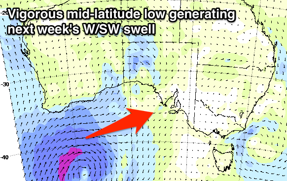
The swell will ease into Tuesday, and early variable winds are likely to swing SW as a deepening mid-latitude low starts encroaching from the west.
This low will form under Western Australia on Monday and aim a fetch of gale to severe-gale W/SW winds through the western Bight before weakening and dipping south-east through Tuesday evening.
A moderate to large W/SW groundswell should be created, kicking very strongly across the Mid Coast through Wednesday afternoon, while the South Coast will be limited in size, kicking to 2-3ft or so late at Middleton with 4ft waves at Waits and Parsons.
 A reinforcing SW groundswell from a secondary weak front moving through our south-west swell window should produce a better swell for Thursday. The only issue are the winds, with fresh and gusty SW tending S/SW breezes Wednesday, from the S'th Thursday and then SE Friday as the swell eases.
Mid Coast: The Mid Coast will be the main beneficiary of this W/SW swell, with a strong kick to 2-3ft expected through the afternoon Wednesday with improving S/SW tending S/SE winds. Thursday should see the swell easing from the 2ft+ range with workable S/SE winds.
Longer term there's another mid-latitude low swell on the cards for early the following week, but more on this Monday. Have a great weekend!

