Good swells to come, limited by average winds
South Australian Forecast (issued Monday 9th November)
Best Days: Mid Coast tomorrow afternoon and Wednesday morning, Mid Coast later Friday and Saturday
Recap
Good solid and improving waves across the South Coast Saturday with plenty of swell leftover from Friday under E/NE tending N/NE winds before afternoon sea breezes kicked in. Sunday was straighter with a smaller easing swell, best suited to Waits and Parsons under N/NE winds, and a weaker sea breeze. The Mid Coast was tiny to flat all weekend.
Today a strong but inconsistent SW groundswell is on the build with this morning's small waves, showing a lot more size and power this afternoon with variable winds on the Mid and strengthening NW winds down South. The swell should peak this afternoon to 3-5ft along the Middleton stretch with 6ft sets at Waits and 1ft+ waves on the Mid, with a late afternoon onshore change on the way.
This week (Nov 10 - 13)
South Coast: Following this afternoon's strong kick in SW groundswell, some more consistent and similar sized surf is due through tomorrow and Wednesday across the coast.
This reinforcing swell has been generated by strong and pro-longed frontal activity on the tail of the 'bombing low' generating today's swell, but with a better alignment for the Mid, and way more consistent for both coasts.
Unfortunately conditions will be poor for the South Coast tomorrow with fresh and strengthening S/SE breezes, kicking up some junky S/SE windswell through the day. Wednesday isn't looking too much better with winds swinging more E/SE but remaining strong.
Size wise, Middleton should dip back to 3-4ft tomorrow morning with 5ft sets at Waits, before kicking back to 3-5ft and 6ft respectively through the afternoon and easing slowly Wednesday from 3-4ft+ and 5-6ft.
As the swell continues to east Thursday, poor S/SW winds are due to spoil conditions again, as a surface trough drifts in from the west. There is a slim chance for variable winds at dawn, but we'll have a closer look at this on Wednesday.
Friday will remain messy and junky with a fresh S'ly onshore and mix of easing S'ly windswell and late arriving W/SW groundswell, discussed below.
Mid Coast: As touched on above, tomorrow's SW swell pulse for the afternoon will be better aligned and we should see 1-2ft sets developing across the Mid into the afternoon with those S/SE winds. A drop is then due into Wednesday from 1-1.5ft with strong offshore E/SE breezes. Thursday is likely to be a tiny 0.5-1ft, with a late pulse of W/SW groundswell to 1-1.5ft likely Friday afternoon but with cross-shore winds.
This weekend onwards (Nov 14 onwards)
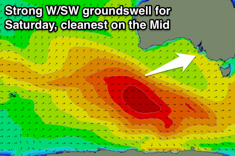
 Friday's late kick in W/SW groundswell will be related to a moderate to large peak in size on Saturday, generated by a vigorous polar low that's formed in the Heard Island region today. This low will track nicely up towards the south-west of WA, generating a fetch of gale to near severe-gale W/SW winds before weakening Wednesday evening and dipping east-southeast under the country.
A strong and powerful W/SW groundswell should result, kicking later Friday and peaking Saturday morning to 3-4ft+ at Middleton 6ft at Waits and Parsons and 2ft on the Mid Coast.
Winds will be best for the Mid and from the S/SE to S/SW, while the South Coast will be onshore and average, with similar conditions due Sunday as the swell eases.
Longer term there's nothing too major on the cards, but check back here Wednesday for an update on this.

