Mix of conditions this week, best Wednesday and Friday mornings
South Australian Forecast (issued Monday 13th September)
Best Days: Tuesday mid-morning onwards both coasts for keen surfers, Wednesday morning South Coast, Friday/Saturday/Sunday morning's South Coast, Monday Mid Coast
Recap
Great weekend for exposed breaks on the South Coast with offshore winds and fun amounts of swell in the 3ft range on the sets. Middleton was small to tiny and great for beginners. The Mid saw tiny 1ft waves for the most part, with the odd bigger one yesterday.
Today the swell was similar again with light offshore winds across both coasts but a W/SW change has now moved through.
This week (Sep 15 – 18)
Tomorrow morning will be worth giving a miss with winds set to still be onshore from the W/SW at dawn, tending variable mid-morning and then remaining so into the afternoon with a small mix of swells.
If you're desperate for a surf the mid-morning session onwards would be the pick with small 2ft sets at Middleton and 3ft waves at Waits and Parsons. The Mid should see 1-1.5ft waves workable on the right surf craft.
Wednesday is looking better for a mission down South with a good new S/SW groundswell due to build through the day. This and following pulses of swell through Friday and Saturday are being generated by initially some strong polar frontal activity under the country today and tomorrow, and then pre-frontal fetches of W/NW gales swinging in from the Indian Ocean.
The best pulse is due Wednesday afternoon and Thursday morning to 3-4ft at Middleton and 4-5ft at Waits and Parsons while the Mid isn't due to see any size above 0.5-1ft.
Winds on Wednesday should be offshore from the N/NE, tending lighter and more variable through the middle of the day ahead of S/SE afternoon sea breezes.
Come Thursday a S/SW change is due to move though, but at dawn winds may be variable, it won't be worth the drive from Adelaide though.
Into Friday the secondary pulses of SW swell are due from the pre-frontal activity, but this is only expected to keep inconsistent 3ft sets hitting Middleton with 4ft+ sets at Waits and Parsons, holding Saturday.
 Winds should be variable and likely tending light N/NE both Friday and Saturday morning's before fresh S/SE sea breezes kick in, so try and get out before lunch both days.
This weekend onwards (Sep 19 onwards)
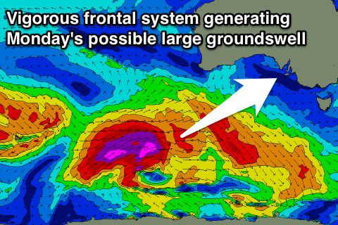
Into Sunday a larger and much stronger SW groundswell is due to start building across both coasts, peaking Monday.
This will be generated by a vigorous polar frontal progression firing up to the south-west of WA Thursday, projecting a fetch of severe-gale to storm-force W/SW winds towards Tasmania, through our south-western swell window.
An initial increase in SW groundswell is due Sunday from an initial strong front firing up just ahead of the main system, building to 3-5ft at Middleton later in the day with 6ft+ sets at Waits and 1-1.5ft sets on the Mid.
A peak is due Monday to 4-6ft at Middleton and 6-8ft at Waits and Parsons with 2ft+ sets on the Mid. Winds are currently looking best for the Mid with a fresh to strong SE-S/SE breeze, but we'll review this again on Wednesday.

