Plenty of westerly swell, cleanest down South
South Australian Forecast (issued Monday 10th August)
Best Days: Tuesday down South, possibly dawn Wednesday both coasts, Thursday down South, Friday down South, the weekend down South
Recap
Great day of waves Saturday down South from Middleton to Waits with a good sized swell and offshores, while Sunday was smaller with stronger offshores, best at swell magnets on the South Coast. The Mid was tiny to flat and generally unsurfable.
Today a low pushing in and across us was whipped up a building W/SW swell from a messy 2ft this morning on the Mid, while the South Coast was tiny and clean, with a mix of SW groundswell and W/SW swell due later this afternoon as winds hold from the W/NW.
 This week (Aug 11 - 14)
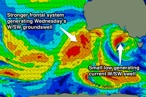
The low currently pushing across us is generating a fetch of W/SW gales through our swell windows, but it'll dip quickly to the south-east this afternoon and evening as an even stronger system approaches from the west.
This should result in the surf dropping back through tomorrow from 3-4ft at Middleton, down to 2-3ft into the afternoon, with 5ft+ sets at Waits and Parsons early, down to 3-4ft into the afternoon. The Mid should ease from 2ft+ or so as fresh to strong N/NW tending NW winds favour the South Coast.
Into Wednesday a large W/SW groundswell is due to fill in, generated by the secondary vigorous frontal system currently pushing up towards WA today and then through the Bight tomorrow.
A broad fetch of gale to severe-gale W/SW winds will be aimed through our western swell window generating a large W/SW groundswell for Wednesday, peaking through the middle of the day/afternoon.
The Mid Coast should see solid 3ft+ waves through the day, while the South Coast should build to 3-4ft at Middleton with 6ft sets at Waits and Parsons.
Winds are tricky, with the front forming into a cut-off low Tuesday evening, resulting in possible variable breezes at dawn, before strengthening from the S/SW as the low pushes east across us.
Thursday will be better down South as the swell eases and winds swing back offshore from the W/NW, favouring protected locations. The Mid will be bumpy and easing from 2-3ft or so.
Friday looks even cleaner, and a reinforcing S/SW groundswell from a polar front will slow the easing trend with dropping 3ft sets at Middleton and 3-5ft sets at Waits and Parsons under NW tending variable winds.
This weekend onwards (Aug 15 onwards)
The weekend looks really fun, with a new strong SW groundswell due to build through Saturday and then ease Sunday with favourable winds.
This swell will be generated by a polar frontal system forming in the south-east Indian Ocean, generating a fetch of pre-frontal W/NW and then post-frontal W/SW gales.
The swell should build Saturday afternoon to 3-4ft at Middleton and 4-6ft at Waits later in the day under N/NW tending variable winds, and then ease Sunday with N/NW tending W/SW breezes. We'll have a closer look at this on Wednesday though.

