Fun week down South, stormy Saturday

South Australian Forecast (issued Monday 6th July)
Best Days: Tuesday for keen surfers both coasts, Wednesday morning down South, Thursday afternoon both coasts, Friday protected spots down South, Saturday afternoon Mid Coast for a stormy, Sunday both coasts
Recap
Excellent weekend of waves with an easing and good sized swell Saturday down South under all day offshores, while a strong and large S/SW groundswell pushed in Sunday offering options from The Dump to Goolwa under fresher N'ly tending NW winds, that then eased into the afternoon. The Mid Coast saw fun 1-2ft waves through the morning before the wind got into it.
Today the S/SW groundswell is on the ease with great conditions again down South, while the Mid was back to a tiny 0.5ft.
 This week (Jul 7 – Jul 10)
Tomorrow is looking a little dicey, with today's S/SW swell due to ease further, as a new small W/SW swell fills in, generated by a weak fetch of W/SW winds currently to our south-west.
This should produce a small 1-2ft wave on the Mid while the South Coast will be easing from 2-3ft at Middleton and 4ft at Waits. Winds are a little dicey but should be workable across both coasts with the trough weakening during the morning resulting in W'ly tending variable winds down South, and SW tending variable winds on the Mid.
Wednesday will be best at exposed breaks on the South Coast and much cleaner but small with a N/NW wind and easing 2ft wave at Middleton with 3ft sets at Waits.
Into Thursday afternoon a mix of long-range and very inconsistent W/SW groundswell along with some more consistent medium-range W/SW swell is due, and N'ly tending variable winds will keep conditions clean all day.
The long-range energy was generated in our far swell window through the Indian Ocean, while the medium-range energy is being generated by a relatively weak frontal system currently south-west of WA.
The morning will be tiny on both coasts, but a kick to 1-1.5ft is due on the Mid into the afternoon with 2ft to possibly 3ft sets at Middleton and 3-4ft+ waves at Waits due down South after lunch.
A drop in size is then due from a similar size Friday morning with freshening W/NW tending NW winds, favouring protected locations down South, while also kicking up 1-2ft of windswell for the Mid.
This weekend onwards (Jul 11 onwards)
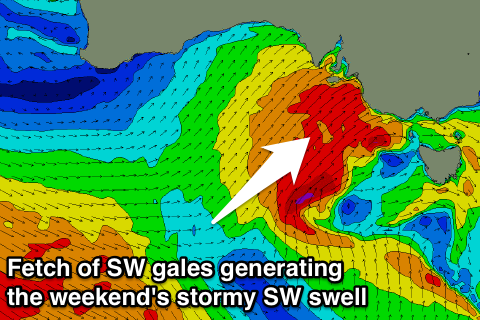
Friday's freshening W/NW'ly will be linked to an approaching change and strong pulse of SW groundswell through Saturday.
A polar front will be steered up from below WA, into the state on Saturday, with a fetch of SW gales producing a large stormy swell through the afternoon.
The Mid Coast should build to a stormy 3ft with strong but easing SW winds, while the South Coast should see 6ft sets developing at Middleton and 6-8ft waves at Waits and Parsons.
We may see conditions improve drastically Sunday as a secondary vigorous front approaching from the west steers winds back to the W/NW and the SW swell eases, but we'll review this again on Wednesday.