Easing surf, fun and small down South over the weekend

South Australian Forecast (issued Wednesday 13th May)
Best Days: Keen surfers down South Friday morning, Saturday and Sunday mornings down South, Tuesday onwards down South
Recap
Average onshore 2ft waves across the Mid most of yesterday, with the South Coast coming in at 4-5ft or so with early W'ly tending W/SW winds.
A very large and powerful SW groundswell started to show into the afternoon though and kicked strongly on dark down South but with poor and strong SW winds. The Cape du Couedic wave buoy readings from this swell (situated off Kangaroo Island's West Coast) are amazing.
A Maximum Wave Height of over 17m was recorded yesterday evening while Significant Wave Heights peaked over 8m along with peak periods of up to 18s. This shows the significance of this swell, one of the largest in some time across the state.
A peak was seen overnight but this morning the South Coast was still a very large and stormy 8ft+ with strong to gale-force onshore winds, while the Mid was a cleaner 2-3ft with a light morning S/SE breeze.
This week and weekend (May 14 - 17)
Last night's large and powerful SW groundswell should continue to ease through this afternoon and further tomorrow, but this will be slowed by a new S/SW groundswell filling in through the day, generated by a strong polar frontal system currently pushing up and into Victoria.
Most breaks should continue in the 4-6ft range through tomorrow but with a strong and easing S/SW breeze, while the Mid is expected to ease from 2ft but with bumpy conditions owing to the S/SW wind.
Friday should become cleaner across both coasts with a fading 1ft to maybe 1.5ft of swell across the Mid and offshore SE winds, while the South Coast will see lighter SE winds creating lumpy and workable conditions. Middleton should be easing from 3-5ft with the odd 6ft bomb still at Waits.
The weekend looks super fun down South with smaller amounts of swell and good winds each morning.
Saturday morning will start slow and small to an inconsistent 2ft at Middleton and 3ft at Waits and Parsons before a new S/SW groundswell fills in, providing a touch more size from midday. Morning NE winds should go onshore from the SE early afternoon.
 A drop in swell is then due through Sunday from 2ft+ at Middleton and 3ft to occasionally 4ft at Waits and Parsons under NE tending E/SE winds. The Mid will be clean but tiny to flat.
Next week onwards (May 18 onwards)
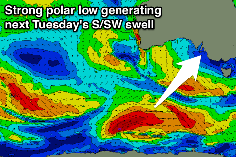
Some fun pulses of S/SW groundswell are due through next week generated by a series of strong polar lows pushing along the Antarctic Shelf in our southern swell window.
A good pulse is due Tuesday ahead of a secondary pulse Wednesday afternoon and Thursday morning with favourable winds from the north.
We'll have a closer look at this on Friday though.