Poor outlook, best on the Mid Sunday through Tuesday, South Coast Wednesday

South Australian Forecast (issued Friday 7th November)
Best Days: Sunday through Tuesday on the Mid, Wednesday down South
Recap
Yesterday was great across both coasts with a mix of W/SW and SW swell coming in at a clean and good 2ft all day across the Mid while the South Coast offered more size to 2-3ft at Middleton with 4ft sets out at Waits.
Today the surf was smaller and easing under strengthening and hot offshore winds, workable early but becoming blowy through the day. We should see winds back off later in the day, so aim for a late paddle for glassy clean conditions.
This weekend (Nov 8 – 9)
The weekend will start off poor as an early morning onshore change pushes in across both coasts around dawn tomorrow creating terrible conditions.
The swell from a deepening but unfavourably tracking low attached to this change has been downgraded with the low expected to be quite weak in nature, resulting in only a small weak increase in SW windswel down South through Sunday with poor S/SE winds.
The Mid Coast however will see a better increase in W/SW swell from the front pushing through the Bight yesterday and today, peaking Sunday at 1-2ft. Winds should be good as well and offshore from the SE Sunday morning ahead of S/SW sea breezes.
 Next week onwards (Nov 10 onwards)
Unfortunately Monday will still be poor across the South Coast as winds strengthen from the S/SE and the swell remains small and weak. The Mid will be clean but tiny and around 1-1.5ft or so.
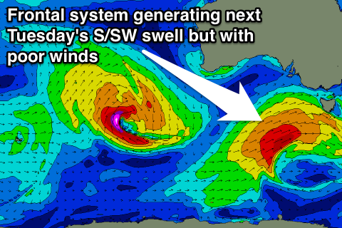
A stronger pulse of W/SW and then S/SW groundswell is due through the afternoon on the Mid, and across the South Coast Tuesday. The W/SW swell will be generated by a pre-frontal fetch of W/NW winds and should keep the Mid ticking at 1-1.5ft through the afternoon before peaking Tuesday morning to 1-2ft.
The better S/SW swell will be generated by a low travelling just behind the pre-frontal fetch, with W/SW tending SW gales being produced through the South Coast's SW swell window.
This should peak Tuesday across the South Coast to 3-4ft+ at Middleton and 5ft+ at Waits but conditions will remain poor with a fresh E'ly breeze.
Wednesday will be the day to surf on the backside of the S/SW swell as a high pressure system moves in, swinging winds around to the N/NE with a dropping swell from 3ft across Middleton and 4ft at Waits.
From here on there's nothing too major on the cards as every swell through the weekend and early next week is due to be spoilt by onshore winds from the southern quadrant, but we'll review this again on Monday. Have a great weekend!
Comments
This sux
Welcome to summer!
I know mate, kills me every year. Is it the wind pattern that screws it all up or a combination of other weather factors?
It's mainly the wind. Swell's are less consistent, but you can still get some decent ones.