Very large stormy swell Friday, cleaner through the weekend
South Australian Forecast (issued Wednesday 30th July)
Best Days: Thursday down South, Friday across both coasts in protected spots, Saturday both coasts, Sunday onwards down South
Recap
A good SW groundswell offered fun 3-4ft waves across Middleton yesterday with strong W/NW winds, while the Mid started a little slow but built to a solid 3ft through the day under average N/NW winds.
Today the swell has held a similar size across both coasts, but lighter NW winds across the Mid early created cleaner conditions. A slight drop in size is expected through the afternoon as winds persist from the NW.
This week and weekend (Jul 31 – Aug 4)
Wave heights are expected to hold a similar size to today into tomorrow morning, but through the afternoon, a rapid spike in new W/SW swell is due, generated by a vigorous mid-latitude front pushing in from under WA this evening, through the Bight and across us through the afternoon.
This should kick the Mid Coast to a stormy 3-4ft into the afternoon, while the South Coast will also jump in size, likely to 4-5ft at Middleton and 6ft+ at Waits (under model forecasts which are combining a separate long-range SW groundswell and the new closer-range W/SW swell).
Winds with this front will become an issue, swinging from a strong NW'ly around to the W/SW through the afternoon.
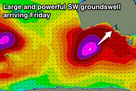
 Into Friday a very large and powerful SW groundswell should fill in across the state, generated just behind the system pushing through tomorrow afternoon.
During today to the south-southwest of WA a very intense polar front is developing and this is forecast to be projected by the Long Wave Trough right up into us while generating a fetch of severe-gale SW winds.
This will generate a large SW groundswell for Friday peaking either side of 10ft on the South Coast from late morning onwards, while the Mid should see stormy 3-5ft waves through the morning before easing later in the day.
Winds will be strong to gale-force from the W/SW tending S/SW but the Victor region may see a short-lived W'ly around dawn.
The weekend is looking much better for surf as the front generating Friday's large swell quickly pushes off to the east and we see a ridge of high pressure move in. This should see winds swinging offshore from the SE across the Mid with an easing 2ft to nearly 3ft of swell, while the South Coast should see winds become variable during the morning and tending light W'ly with a large easing swell. Middleton should be dropping from 6ft+ or so with 8ft sets at exposed breaks.
Sunday looks a lot better down South with an easing S/SW groundswell from 3-4ft at Middleton and 4-5ft at Waits under moderate to fresh NW winds.
Next week onwards (Aug 4 onwards)
We've got a good run of waves and winds into next week as a large blocking high sits across most of the country, directing light winds across most coasts, but the frontal activity will continue around this high. We should see some medium sized plus pulses of SW groundswell through next week with favourable winds, but we'll discuss this in more detail on Friday.

