Lots of swell for the next couple of weeks

South Australian Surf Forecast by Ben Matson (issued Wednesday 21st May)
Best Days: Thurs/Fri: easing swell with good winds down south. Sat/Sun: new S/SW swell with offshore winds down south. Sun: keep an eye out for a small long period SW groundswell on the Mid in the a'noon.
Recap: Great waves everywhere although easing today from a peak yesterday afternoon. Great conditions with light winds.
This week (May 22-23)
*note: forecast notes will be somewhat brief this week as Craig is on leave*
Looks like we’ve got a temporary lull in swell activity for the rest of the week. The current mix of easing S/SW and residual SW groundswell will continue to fade through Thursday and Friday, leaving very small waves on the Mid Coast but still decent options at the exposed beaches at Victor.
Fresh NW winds down south will keep conditions clean for much of Thursday, although they’ll become quite gusty as a small front passes just south of the state.
Winds will then tend variable on Friday as a high moves in from the west. Small surf will pad out most of the day but a new S/SW groundswell is expected to arrive on the South Coast late afternoon that should kick up some 3ft sets at Middleton by dusk.
Unfortunately, this swell direction won’t be beneficial for the Mid Coast so we’ll see continuing small residual energy here all day. That being said there should be enough for an occasionaly tiny longboard wave on the reefs, or something on the beachies for beginners.
This weekend (May 24-25)
We’ve got a great weekend ahead for the South Coast, with offshore winds and a decent long period S/SW groundswell for Saturday that’ll ease slowly through Sunday. Wave heights should hold the 3ft mark at Middleton with bigger sets at Goolwa and Waits, however the distant source of this energy will mean there’ll be quite a break between the bigger waves. Expect smaller, less consistent surf through Sunday but of a similar quality level.
Unfortunately, no great surf is expected on the Mid Coast on Saturday, with just more of the same residual energy hovering around half to maybe one foot, very weak and inconsistent.
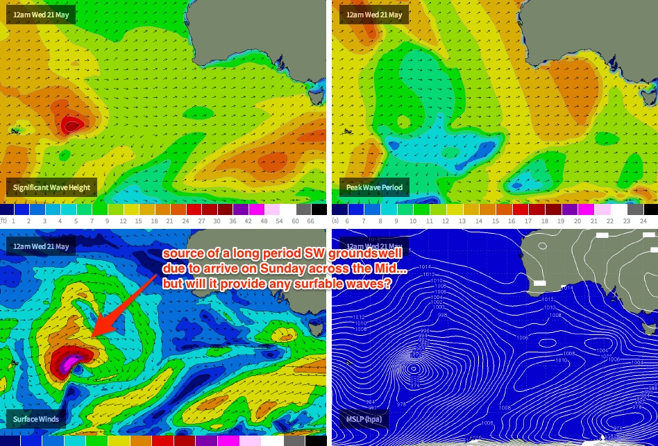
Sunday will see the arrival of a very long period SW groundswell being generated by an intense storm many thousands of kilometres away (currently east of Heard Island, see the chart below). However the bulk of this energy is expected to push through on Monday, and the enormous travel distance will keep a lid on size prospects in the gulf. That being said, it’s possible that we may see some infrequent waves building to (perhaps) between 1ft and maybe 2ft late in the afternoon if we’re super lucky. And with twenty minute breaks between sets too.
Right now I’m not especially confident for this swell to happen, so I’d recommend a Victor mission on Sunday - but keep an eye on the CdC buoy in the morning, and the South Port surfcam around lunchtime - and make the dash back in the afternoon if it starts to show signs of building.
Longer term (May 26 onwards)
We’ve got a very complex forecast period ahead for the state. Over the weekend a strong cut off low is expected to migrate slowly through the Bight. Right now, there’s a large range in solutions being offered by the computer models - some have a strong band of westerly gales sliding south of West Oz, which would lead to a large W/SW swell across the region early next week (favouring the Mid Coast).
However other models have a weaker, disjointed W’ly flow which may not generate much size. We’ll have to wait and see how the models resolve this situation over the coming days before having any confidence in the outlook, but gut feel tells me we’re looking at a moderate, windy swell building through Monday and Tuesday (on top of a small long period groundswell mentioned above for Sunday afternoon), with a chance for strong secondary fronts to grace the region later in the week (bringing more W/SW swell).
Elsewhere, and the computer models are also suggesting that the polar region where the current (and incoming) S/SW swells were formed (between 120-145E) may reactivate early next week with the formation of a vigorous low pressure system. It may possibly even merge with the latter stages of the cut off low in the Bight; either way resulting in a broad fetch of SW gales aimed right into the South Coast’s swell window.
If this eventuates, we could be looking at large windy surf across the Victor coast Wed/Thurs next week. However, due to the divergence between the models we really need a few more days to make a proper assessment. I’ll take a closer look at this in Friday’s notes.