Small windows of opportunity in between strong onshores

South Australian Forecast (issued Friday 2nd May)
Best Days: Sunday down South, Wednesday morning, Thursday
Recap
Yesterday was excellent down South with a solid easing swell and all day offshores offering plenty of options from Goolwa to Parsons. The Mid Coast was glassy early, with a dropping 2ft of swell, but winds swung onshore and increased during the day, creating average conditions.
Early this morning a SW change moved through, creating poor 2ft waves on the Mid, while Victor saw a very short-lived period of W'ly winds before swinging SW. A semi-stormy swell should kick up to 2ft to possibly 3ft this afternoon on the Mid, while the South Coast should also see an increase in swell but with no quality.
This weekend (May 3 – May 4)
A deepening low pressure system across Victoria is responsible for today's strong onshore change and we should see this system moving off slowly to the east during the weekend resulting in an improvement in winds but not until Sunday.
Through tomorrow though, a peak in medium sized SW groundswell is due across the state to 2ft on the Mid and 3-5ft at Middleton with 4-6ft sets at Waits. Conditions will be poor though with a persistent fresh to strong S/SW wind.
Sunday however as the swell eases from 2ft on the Mid and 3-4ft at Middleton with 4-5ft sets at Waits, should see light NW winds developing during the morning and holding into the afternoon, favouring Middleton and the breaks around Victor Harbor. The Mid Coast should be glassy and possibly lumpy with a light variable breeze.
Monday onwards (May 5 onwards)
Monday will only offer a brief period of offshores down South from the W/NW before a S/SW change moves through during the morning, associated with a deepening low pressure system pushing towards Tassie.
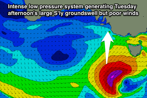 This low is expected to generate a fetch of gale to severe-gale S/SW winds in our southern swell window (pictured right), generating a large sized S'ly groundswell for Tuesday afternoon to 6ft+ across most spots, while the Mid Coast won't see much size at all with the S'ly swell direction.
Winds will be poor though with a fresh SE tending S/SE breeze, while Wednesday is looking better with a morning E/NE'ly.
Thursday will be the best down South with a morning NE'ly and fun swell for Waits/Parsons and the Middleton to Goolwa stretch.
Longer term the outlook is a little hazy with the models diverging on how the westerly storm track will shape up through the end of next week, but check back here on Monday for the next update.