NW winds persist as large swell eases
Nias, Mentawai, South Sumatra forecast by Craig Brokensha (issued Tuesday 19th July)
Best Days: Protected breaks out of the NW wind Wednesday and Thursday, more exposed breks from Friday as winds tend N/NE and then ease
This week and next (Jul 20 - 29)
Since the weekend we've seen large pulses of S/SW groundswell impacting the islands, ebbing and pulsing with each swell cycle.
Today the largest of all the pulses should be filling in with sets due to reach 8-10ft by dark this evening (with the chance of some bigger cleanups), easing back from a similar size tomorrow morning.
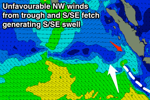
Unfortunately fresh NW winds linked to a surface trough sitting to our south is severely limiting surfing options across the region.
 These NW winds are due to persist through until Friday when the trough weakens and winds tend N/NE and then variable over the weekend.
The S/SW groundswell will continue to ease through Thursday from 6ft to possibly 8ft across south facing breaks, smaller into friday.
Some new S/SW groundswell is due later Friday but more so Saturday across the region, generated by a cold front currently projecting north-northeast up through the Indian Ocean.
The swell off this system looks to come in around 4-5ft+ across exposed south facing breaks, with some mid-period S'ly swell also in the mix from a broad and persistent fetch of S/SE winds to our south over the coming days.
Into Sunday similar sized surf is due, with our models incorrectly combing the mid-period and long-period energy.
Monday, the mix of S'ly swells should start to ease back from 4-5ft under variable breezes, tending S/SE if anything.
Some acute and small to moderate pulses of S'ly groundswell are due later Tuesday/Wednesday and later Thursday/Friday from a couple of strong polar lows forming late in our swell window and not really tracking favourably at all.
With this only inconsistent sets to 3-5ft are due at south swell magnets, smaller into the following weekend.
Longer term there's nothing too major on the cards as a series of blocking highs deflect any major frontal systems away from us and through our southern swell window. There is a possible moderate sized plus swell for mid-next week but more on this Thursday.
16 day Mentawai forecast graph
16 day Nias forecast graph
16 day South Sumatra forecast graph

