Easing surf ahead of large S/SW groundswells from Sunday
Nias, Mentawai, South Sumatra forecast by Craig Brokensha (issued Thursday 14th July)
Best Days: Friday morning, later Saturday, Sunday onwards for experienced surfers
This week and next (Jul 15 - 22)
A moderate mix of S/SE and S/SW groundswell energy is breaking across the coast today and we'll see both these swells ease through tomorrow and bottoming out Saturday morning as winds persist from the north-western quadrant.
Into Saturday afternoon some new S/SW groundswell energy is expected to build, the beginnings of a large pulse due to peak Sunday.
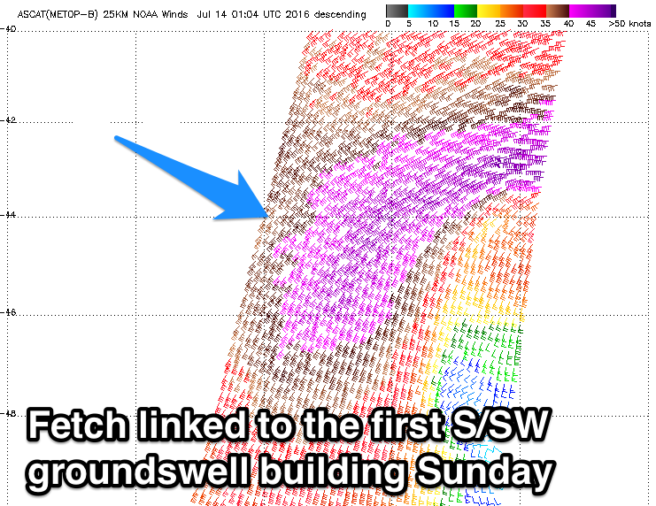
 This groundswell and a series of large follow up S/SW groundswells are developing under a strong node of the Long Wave Trough that's strengthening through the Indian Ocean.
An initial broad fetch of gale to severe-gale SW winds projecting towards eastern Indonesia (right) has generated a large S/SW groundswell for Sunday. A kick to 5-6ft is likely on dark Saturday across south facing breaks, peaking Sunday to 8ft+.
A drop in size is due overnight Sunday, further into Monday from 6ft to possibly 8ft during the morning.
Into Tuesday morning a reinforcing pulse of S/SW groundswell is due, generated by a secondary fetch of gale to severe-gale SW winds projecting north-east towards Indonesia from the Heard Island region.
This fetch will move over an already active sea state, producing a large S/SW groundswell to 8ft to possibly 10ft at south facing breaks, again easing slightly through the day.
 The largest pulse of all will be generated by back to back fetches of SW-S/SW winds pushing quite far north up and towards eastern Indonesia during Friday and Saturday.
A large consistent S/SW groundswell will be produced, but with a touch more south in it than the previous swells.
This swell may be seen later Tuesday ahead of a peak Wednesday morning to 8-10ft+ across exposed south facing breaks, easing through the afternoon and further down into Thursday and Friday.
Variable winds are due to develop into Sunday and Monday, with NW'ly breezes freshening into Tuesday and Wednesday, limiting options across the region. A return to lighter winds is then expected late week.
Longer term some new large S'ly groundswell is likely the following weekend, but more on this Tuesday.
16 day Mentawai forecast graph
16 day Nias forecast graph
16 day South Sumatra forecast graph


Comments
Hi Mate going to telos sat 30th for the week any idea on swell for that week cheers
Hi Pete, here's the latest update: NW winds persist as large swell eases
Pete, you still living in the most beautiful little town in the world?